Showing posts with label maps. Show all posts

Monday, May 22, 2017

Chisholm Trail

Kansas State University is celebrating the legendary cattle trail’s sesquicentennial with a notable exhibit featuring historic books, music, photographs, maps, cowboy attire and artifacts. “Chisholm Trail: History & Legacy” is a collaboration between the Libraries’ Morse Department of Special Collections, the K-State College of Human Ecology’s Historic Costume & Textile Museum, and the Kansas City Museum.

The exhibit focuses on Kansas cattle towns, trailblazers, ranchers, farmers, drovers, lawmen and outlaws. It includes historic railroad and Indian Bureau maps, wood engravings, stereocards, advertisements and first-hand accounts of the trail that brought Texas cattle to Kansas markets.

The free exhibit runs through October 13, 2017 in Hale Library's Fifth Floor Gallery.


Kansas State University Libraries is home to William J. Keeler's incredibly scarce 1876 National Map of the Territory of the United States from the Mississippi River to the Pacific Ocean (detail above). Printed under the authority of then-Secretary of the Interior Orville Hickman Browning (1806-1881), the map documents the locations of tribal and ceded territories, leases and trusts. It reveals the westward expansion of the nation's Public Land Survey System, its overland mail route and its railways.

Map, detailed above:

William J. Keeler. National Map of the Territory of the United States from the Mississippi River to the Pacific Ocean Made by the authority of the Hon. O.H. Browning Secretary of the Interior. In the Office of the Indian Bureau Chiefly for Government Purposes under the direction of the Hon. N.G. Taylor Commise. of Indian affairs & Hon. Chas. E. Mix Chief Clerk of the Indian Bureau. 1876. Detail. Richard L. D. & Marjorie J. Morse Department of Special Collections, Kansas State University Libraries.

Thursday, October 20, 2016

Segregation Forms: Redlining


The University of Richmond's Digital Scholarship Lab has developed a fantastic resource that provides access to hundreds of so-called "security maps" created between 1935 and 1940. The product of the Home Owners' Loan Corporation [HOLC], the maps and area descriptions represent the neighborhood risk assessments generated by mortgage lenders, developers and real estate appraisers. HOLC's analyses were the basis for what came to be referred to as redlining, segregationist housing and real estate practices.

Image above: Wichita Mapping & Engineering Company. Wichita, Kansas. 29 May 1937. Robert K. Nelson, LaDale Winling, Richard Marciano, Nathan Connolly, et al. "Mapping Inequality," American Panorama, ed. Robert K. Nelson and Edward L. Ayers, accessed 20 October 2016, https://dsl.richmond.edu/panorama/redlining/#loc=5/36.704/-96.943&opacity=0.8.

Friday, April 8, 2016

The Kansas Module (1887)

William H. Sadlier Company published the first two volumes of its Excelsior Geography in 1875. An additional volume appeared the following year. The works were part of a series that the Sadlier family developed to serve parochial school educators who lamented the anti-Catholic sentiment they discerned in American textbooks.

Sadlier's secondary school publications became quite popular, and garnered attention at the 1878 Paris Exhibition. Many went through multiple editions, as did its three-volume geography primer.

The plate reproduced above, "Map Drawing on a Uniform Scale, Combined with Comparative Size," provides general instructions based on a uniform scale. The anonymous author set Kansas as the basis for mapping out the other states, the rectangular module for the United States. Its proportional relationship of 1:2 (200 miles x 400 miles) made it particularly easy to scale. For those states with more irregular borders, the author recommended employing comparative size.

See more geography instruction manuals here.

Image above:  "Map Drawing on a Uniform Scale, Combined with Comparative Size." As it appears in Anonymous ["A Catholic Teacher"]. Sadlier's Excelsior Geography, 2nd ed. New York: William H. Sadlier, 1887. Ben A. & Sylvia S. Smith American Geography and Social Studies Education Collection, Richard L. D. and Marjorie J. Morse Department of Special Collections, Kansas State University Libraries.

Thursday, April 7, 2016

States on Stage (1884)

Chicago designers Trowbridge and Petford developed this advertising map for H.W. Hill & Company, the nation's largest manufacturer of hog rings. Hill had utilized the cartographic format for a previous promotional effort, his Map of the United States, Showing the Farm Animals in Each State (1878).

While the earlier ad incorporated Department of Agriculture data, the 1884 map employed cartoonish pigs to represent each state's common nickname. William Eugene Sutphin Trowbridge, a designer, and Charles E. Petford, the Haverly Theatre's scenic artist, combined forces for Hill's Advertising Department.  They created a colorful map revealed through stage curtains by a porcine clown and an impresario.

Dakota Territory and Louisiana are the only regions that feature architectural elements, with a Native American tepee representing "In the Land of the Dakotas" and an ornamental balustrade suggesting the Creole state. Iowa's Hawkeye has a bird's eye view of a railroad bridge, a steamboat and a distant town. Vermont's "Granite State Boys" features a monumental pig statue.

Potential customers could purchase the map for merely 5¢.

Image above:  Nicknames of the States. Decatur, IL: H.W. Hill & Co., 1884. Library of Congress Prints & Photographs Division. URL:  http://www.loc.gov/pictures/item/2003671557/

Friday, February 12, 2016

NYPL - NEW Digital Resource

Brian Foo with the New York Public Library has developed a great interface for digital content gleaned from NYPL and University of South Carolina resources. With guidance from the Schomburg Center for Research in Black Culture, the team generated heat and cluster maps based on Victor Green's automobile travel directories.
Consulting the 1947 cluster map, one can then link to the digital Negro Motorists' Green Book of the same year.

At that time, Manhattan, Kansas had two Yuma Street tourist homes that catered to black travellers. Kansas City was a regional epicenter, with beauty parlors, a country club, garage, hotels, night clubs and tourist homes.

Consulting the 1956 cluster map reveals that while Manhattan venues remained virtually the same, options had diminished quite a bit in Kansas City.

Of course, highways have changed and many regions did not provide amenities, so the interface that allows you to map from one location to another based on the 1947 and 1956 guides may yield some wonky results.  Try going from New York City to Grand Forks, ND and see where the pathfinders take you.


Images above:  NYPL Labs. Navigating the Green Book. Screen shots captured 12 February 2016. Main URL:  http://publicdomain.nypl.org/greenbook-map/index.html

Friday, December 18, 2015

New Orleans As Divine Feminine

In 1915, New Orleans bungalow architect Morgan Dudley E. Hite (1882-1959) developed a map titled "New Orleans --Center of the World" (shown above). Mayor Martin Behrman's administration liked the map so much, it was used in a full-page advertisement the following year (shown below), accompanied by the passage:

"New Orleans is not content to rest secure and apathetic in her position as the center of the world, the center of world population, the center of world-production, the center of world-navigation.

"That much was done for the City of New Orleans by Nature.

"But to supplement this handsome and generous work of Nature the City of New Orleans is building for the future when the new industrial empire at her door will have been developed; when the wet lands at her door have been reclaimed; when the cut-over pine lands will have been turned to the plow; when the natural resources of her tributary section will have been made to yield the golden tribute of their promise."(1)

(1)"The Eyes of the World Are on New Orleans." Trade Index 28:6 (June 1916); recto of back cover. Louisiana Research Collection, Special Collections Division, Tulane University Libraries.

Tuesday, November 24, 2015

Old Marrero Cemeteries

Continuing on yesterday's theme regarding placing and dating historic cemeteries in southeastern Louisiana. . .

Civil engineer (c.e.) James Webb platted the so-called Robinson Avenue Subdivision in early 1921. He based his map on two existing plans, one that c.e. H.L. Zander developed in 1915 (reproduced above as "Exhibit A"); and one that J.W.T. Stephens created in 1919. For surveyors, crediting earlier surveys is an important part of the process: the quality of a new plat depends on the accuracy of its sources.

Zander had attempted to establish the Arpent Tract between the Southern Pacific Railroad and the new Amesville Highway.(1) Identifying the cross-axial artery as "Robinson Lane," Zander referenced the former land holdings of the Robinsons and the Dennises. He also measured two historic cemeteries, one he referred to generically and the other he identified as the St. Joseph Cemetery.

Both cemeteries appear on the Sanborn Fire Insurance Atlas of 1937, which I manipulated below. "A" is the St. Joseph Cemetery and "B" is the unnamed one.

St. Joseph Cemetery is still extant (333 Robinson Avenue) and has been expanded towards its originating worship space. Its historic neighbor is now a near-empty lot.


(1)This later became part of the Jefferson Highway, and today is referred to as Fourth Street.

Images above: Digitally enhanced detail of James Webb, c.e.. Robinson Avenue Subdivision. New Orleans: 5 May 1921. Blue line copy, from Guy Seghers Office Records, Southeastern Architectural Archive, Special Collections Division, Tulane University Libraries. Box 119. Folder 30.

Digitally altered detail of Sanborn Fire Insurance Atlas. Volume 7 [true 11]. Sheet 1119. New York: 1937. As viewed via Digital Sanborn Maps Database, available at Tulane University Libraries.

Wednesday, November 11, 2015

Loeper's Park (1879-1901)

We recently came across mention of Loeper's Park, located on two municipal squares in the Second District, marked "A" and "B" above. The park served picnickers, social clubs, veterans' groups, baseball players and performing artists. It was located on ridge land, and its alignment along the railroad track that served the Spanish Fort meant that those seeking entertainment venues could easily* jump on/off along this corridor.

The upper section of the park was a "concert garden" shaded by mature live oaks, mulberry and acorn trees. It had shelled drives and walkways, and was outfitted with a 100 x 90' dancing platform.

The lower section served as a baseball park. Various "Niners" battled it out here:


August 1879              Dr. Szabary Nine v. Lightning Nine

April 1891                 B. Landau & Co. Nine v. L. Goldstein & Sons Nine

September 1891         Asphalts v. Rosettas


In 1901, the park accommodated cornetist Oscar M. Giovanni and the "Colored People's Family Resort Minstrel Show." It served as the meeting place for the Ninth Regiment U.S. Volunteer Infantry (AKA "The Ninth Immunes"), the city's Spanish-American War veterans.(1)

*Sometimes not so easily, as attested to by various state tort claims.

(1) For more on the Immunes, see W. Hilary Coston. The Spanish-American War Volunteer. Middletown, PA: By the author, 1899. E725.7.C8 Louisiana Research Collection, Special Collections Division, Tulane University Libraries.

and

Fletcher, Marvin. "The Black Volunteers In the Spanish-American War." Military Affairs (April 1974): pp. 48-53.

Image above:  Index map. Digitally enhanced detail. Atlas of the City of New Orleans, Louisiana, based upon surveys furnished by John F. Braun, surveyor and architect, New Orleans. Published by E. Robinson, New York. [AKA The Robinson Atlas]. 1883. Southeastern Architectural Archive, Special Collections Division, Tulane University Libraries.

Wednesday, November 4, 2015

Architectural History Viewer

University of Wisconsin-Madison's Garrett Dash Nelson has developed a wonderful architectural history timeline/map interface. He created the map by using some 62,400 Madison property records that he geolocated in 2013. Structural identifications include stylistic categories and building typologies.

Access the map here.

Image above:  Garrett Dash Nelson. Madison Architectural History Viewer.  Ongoing project. As viewed October 2015.

Tuesday, July 21, 2015

1925 Shreveport Fire

In early September 1925, a devastating fire swept through Shreveport's historic Allendale neighborhood (detail above). Ironically, it originated at the Garden Street rental property owned by retired fire chief Chris O'Brien.

Strong winds carried the fire northeast, bounded by the Texas & Pacific Railroad. Firemen responding to the alarm -- from the engine house across the street -- arrived only to discover they had no access to water. In the map detail below, the fire station is marked in red, O'Brien's property is marked in white.

Contemporary accounts cite a water main failure several hours earlier as the primary cause of the fire's destructive growth. Rumors of criminal negligence circulated and racist reporting claimed a jazz dirge on a player piano accompanied the neighborhood's destruction.(1)

When the fire was contained at the T & P's main line, there had been at least two fatalities, nearly 200 homes were destroyed, and some 1200 residents displaced. African-Americans and recent immigrants comprised the majority of the victims. Insurance adjusters reported that only 60% of the losses were covered by policies.(2)

The Southeastern Architectural Archive's Map of the Area Involved in Conflagration at Shreveport, LA (shown above) was issued by the Louisiana Fire Prevention Bureau in New Orleans. We recently discovered it accordion-folded and hidden away inside the binding of a Sanborn Fire Insurance Atlas. The cartographer mapped out the fire's source, the wind direction and all of the "risks" (i.e. structures) that were destroyed.

A recent Washington Post blog addressing racial divides across American cities highlighted Shreveport and it reminded us of our "Conflagration" discovery.

Utilizing Dustin Cable's Racial Dot Map, WP blog authors Emily Badger and Darla Cameron discussed historic transportation arteries in the context of racial segregation.
From Cable's map, we cropped the Allendale fire and surrounding neighborhood in the detail above. Note that Texas Avenue largely follows the perimeter of the old T & P line.

(1)"Negro Apes Nero, Playing Piano as Shreveport Burns." The Times-Picayune 7 September 1925.

(2)"Losers in $700,000 Fire Paid $358,885."  The Times-Picayune 7 October 1925.

Images above:  Two Details, Louisiana Fire Prevention Bureau. Map of the Area Involved in Conflagration at Shreveport, LA. New Orleans, LA:  1925. Fire Insurance Atlases, Southeastern Architectural Archive, Special Collections Division, Tulane University Libraries.

Detail. Dustin Cable. Racial Dot Map. Demographics Research Group, the Weldon Cooper Center for Public Service, University of Virginia, 2013.


Wednesday, June 3, 2015

Holly Springs Iron

In 1860, Holly Springs, Mississippi (1858 map detail shown above) began to garner attention in the Gulf South as a source for ornate iron facades. Wallace Scott McElwain (1832-1883) had established a foundry partnership with Wiley Jones and E.G. Barney just one year earlier. The completion of the Mississippi Central Rail Road to New Orleans made direct shipments of iron castings to the Gulf possible.

In March 1860, The Mississippian announced that Jones, McElwain & Company had received a contract "with some citizens of New Orleans" to deliver $65,000 work of iron for a large hotel project.(1) That same month, D.I. Ricardo notarized a $100,000 building contract between Wm. McElvain [sic] and John G. Barelli for William A. Freret's Moresque building.(2) One year later, the company received two contracts for iron store facades located in Square 171 of the First Municipal District.(3) The first, for Hugh W. Montgomery, featured abundant Gothic Revival ornamentation on its Camp and Common Street facades (Camp Street detail shown below).(4)

The second, for Thomas C. Herndon, was based on plans by William A. Freret. This structure was later replaced by Thomas Sully's New Orleans National Bank.
In February 1862, the Confederate States of America acquired the Jones-McElwain foundry. An 1861 War Department map -- digitized by the Library of Congress (detail above) -- is annotated to indicate the strategic locations of Holly Springs and Oxford along the Central Rail Road line.  In November 1862, the Union Army took over the complex and briefly used it for munitions storage until Confederate General Earl Van Dorn's action raid on Holly Springs resulted in its destruction.


(1)"A Large Contract." Mississippian 23 March 1860.

(2)"Building Contract." D.I. Ricardo. 1860, March 5. MOB 77, f. 246 and 46?, as cited in Building Contracts, Samuel Wilson, Jr. Papers & Drawings, Southeastern Architectural Archive, Special Collections Division, Tulane University Libraries.

(3)"Building Contract." T. Guyol. 1861, 14 March. Vol. 49, No. 148 and "Building Contract." T. Guyol.1861, April 10. Vol. 49, No. 214, as cited in Building Contracts, Samuel Wilson, Jr. Papers & Drawings, Southeastern Architectural Archive, Special Collections Division, Tulane University Libraries.

(4) It was demolished in the 1950s, when the L-shaped property sold to the Whitney Bank for us as a drive-through.

Images above:

G.W. Colton and Richard Swainson Fisher. Mississippi, Louisiana and Arkansas. Inset: Vicinity of New Orleans. New York: 1858. Detail. David Rumsey Map Collection. URL: http://www.davidrumsey.com/

Unidentified photographer. 207 Camp Street. Circa 1955. Detail. Visual Materials Collection, Southeastern Architectural Archive, Special Collections Division, Tulane University Libraries.

United States War Department. Map of the Alluvial Region of the Mississippi. 1861. Detail. Civil War Maps, Library of Congress. URL:  http://www.loc.gov/collection/civil-war-maps/about-this-collection/

Tuesday, May 26, 2015

Upcycle Pioneer (1944)

In 1941, Hazel Dell Brown (c. 1892-1982), the chief interior designer for Armstrong Cork Company, penned her first Album of Room Ideas. She followed with subsequent albums, each time making creative suggestions to readers, and soliciting their written questions. For her 1944 "new approach to kitchen design," Brown developed an "all-in-one" scheme hidden behind a "home-painted" bird's eye view of the town (shown above).
Utilizing corner and wall cupboards to maximize storage space, Brown was able to combine storage bins, pan/utensil holders, shelving and additional counter space.

She harmonized linoleum colors with the painted elements, textiles and comestibles.

Brown collaborated with Sears-Feibleman's interior decorator Lucille Gray to create "Honeymoon Home," Armstrong Cork's New Orleans model residence. Built on the corner of Webster and Benjamin Streets near Audubon Park, the Honeymoon Home opened to the public in July 1937.

Images above:  Brown, Hazel Dell. Album of Room Ideas [Armstrong Linoleum]. N.p.: Armstrong Cork Company, 1944. TS 1779.L5 B76 1944. Architectural Trade Catalogs, Southeastern Architectural Archive, Special Collections Division, Tulane University Libraries.

"Honeymoon Home." Times-Picayune advertisement. 31 July 1937.

Thursday, March 5, 2015

KUDOS to the Digital Commonwealth. . .

For digitizing the Norman B. Leventhal Center map collection. The Center, part of the Boston Public Library system, is dedicated to the creative educational use of its cartographic holdings. They have created a fantastic GIS-based interface.

The map reproduced above is an inset map titled Plan de la ville de la Nouvelle Orleans telle quélle était en mai 1728, and it includes the names of property owners for  Vieux CarrĂ© structures originally documented by the French cartographer Jean-Baptiste Gonichon.

Image above: Francis Barber Ogden, cartographer; Peter Maverick, engraver. Inset map from To General Andrew Jackson and his brave companions in arms on the 8th of Jany. 1815 this plan of the city of New Orleans is respectfully dedicated. 1829.Map reproduction courtesy of the Norman B. Leventhal Map Center at the Boston Public Library.

Wednesday, February 11, 2015

Place Logic


For those undertaking place-based research, the following guides may be beneficial:

"Maps & GIS." Architecture Research Guide. Tulane University Libraries. Last updated 11 February 2015.

"Regional Research." Architecture Research Guide. Tulane University Libraries. Last updated 11 February 2015.

Barrett, Brien & Genya Erling.  "Learning to Do Historical Research: Sources/MAPS: Visualizing Place, Space, and Time." Last viewed 11 February 2015.

Cote, Paul. "Extending the GeoWeb: Georeferencing Site Photos." Harvard University Graduate School of Design. Last viewed 11 February 2015.

Image above:  Esso Standard Oil Company. "Downtown New Orleans and the Vieux CarrĂ© (Old French Quarter)." Arkansas, Louisiana Mississippi, With Special Maps of New Orleans and South Central States. Convent Station, NJ: General Drafting Company, Inc., 1954. Private collection.

Tuesday, February 10, 2015

1883 Robinson Atlas

The Southeastern Architectural Archive (SEAA) and the Tulane University Libraries' Preservation Department recently completed an exciting conservation project. An important New Orleans fire insurance atlas has been cleaned, mended and housed in a custom-made protective enclosure. It is now accessible to researchers for the first time in decades. Known most commonly as the Robinson Atlas, the work was published under the title Atlas of the City of New Orleans, Louisiana, based upon surveys furnished by John F. Braun, surveyor and architect, New Orleans.

Based on district maps that architect-surveyor John Braun developed in the 1870s, the Robinson Atlas represents the finest in accurate insurance mapping. It was printed in Philadelphia by A.H. Mueller and F. Bourquin and published by New Yorkers Robinson & Pidgeon. The latter produced a number of municipal fire insurance atlases in the early 1880s, the most notable of which are the ones for Chicago, New Orleans and New York.

Individual sheets are lithographed. Text blocks were engraved by A.H. Mueller.

Although the New Orleans Notarial Archive digitized its Robinson Atlas many years ago, it did not include the index maps that provide critical content, including the map key. The SEAA's holdings include two index maps, and both variants have been conserved.

Image above:  Index map. Detail. Atlas of the City of New Orleans, Louisiana, based upon surveys furnished by John F. Braun, surveyor and architect, New Orleans. Published by E. Robinson, New York. [AKA The Robinson Atlas]. 1883.


Tuesday, December 23, 2014

Harvey Murdock in Bogalusa

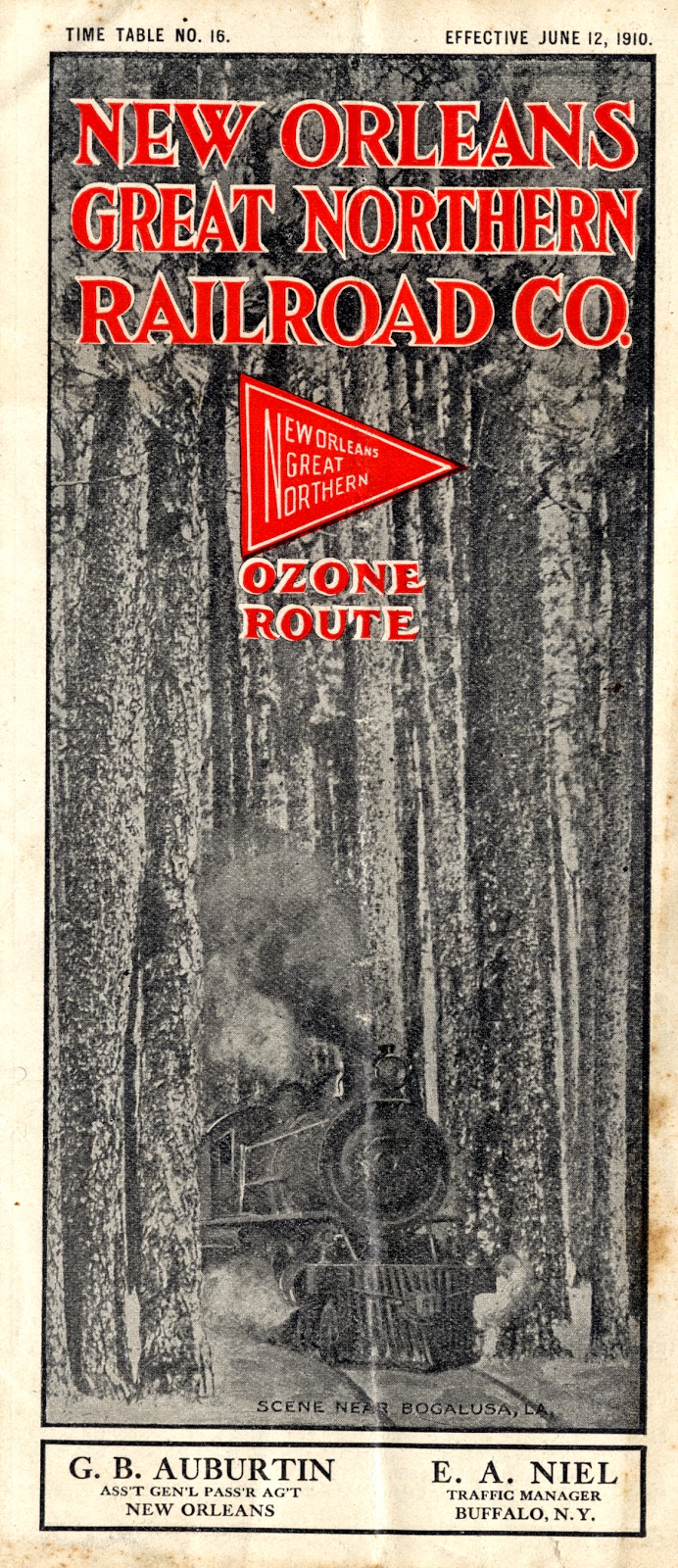
 108 years ago, The Daily Picayune reported on New York architect Harvey Murdock's appearance in Bogalusa, Louisiana to superintend the construction of six station houses for the New Orleans Great Northern Railroad.  With links to the Great Southern Lumber Company, the "Nogan" established track to link Slidell to lumber operations in Bogalusa, with extended links to Jackson, Mississippi.

Murdock (†1922), a builder and developer most known for Brooklyn and Manhattan row houses, was given the task of designing the section houses at intervals every seven miles along the system. Section houses consisted of foremen's residences and laborers' houses. He also drafted plans for general office buildings and shops in Bogalusa.

As we reported in an earlier post, New Orleans architect Rathbone DeBuys worked on designs for Bogalusa during the second decade of the twentieth century.


For more information, see: "Great Northern Begins Work on Line to Jackson."  The Daily Picayune 25 December 1906.

Images above:  New Orleans Great Northern Railroad Co. Route Map & "Scene Near Bogalusa, LA" Cover. Time Table No. 16, Effective 12 June 1910. Martin Shepard Office Records, Southeastern Architectural Archive, Special Collections Division, Tulane University Libraries.

Friday, November 14, 2014

Edgewood Park

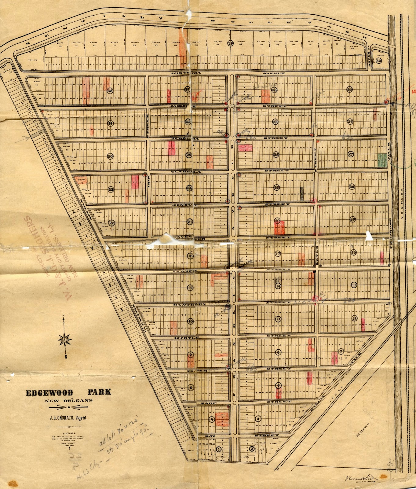
This fall the National Park Service approved New Orleans' Edgewood Park neighborhood's inclusion on the National Register of Historic Places. The subdivision was developed in 1909 on the former Dennis Sheen Tract, originally bounded by the Louisville & Nashville Railroad, the New Orleans and Northeastern Railroad, Gentilly Boulevard and Clematis Avenue. This tract was desirable pasture land covered in blackberry bushes and grass, located along a natural ridge. Real estate developer J.L. Onorato secured an option on the property in February 1909. The following month, the New Orleans Railway Company announced it would extend its Villere streetcar line a mile beyond the Franklin Avenue/Galvez Street stop in order to provide service. Soon thereafter, consulting engineer Warren B. Reed platted the subdivision with all lots measuring 30' x 120'.  Early purchasers had a tendency to buy two adjacent lots (map above). By spring of 1910, Onorato sold a large number of Edgewood's remaining lots to Grover & Leyman, an Indianapolis-based real estate investment firm.

The neighborhood includes a large number of bungalows.

Image above: William Reed, consulting engineer. Edgewood Park, New Orleans. /J.L. Onorato, Agent. May 1909. Guy Seghers Office Records, Southeastern Architectural Archive, Special Collections Division, Tulane University Libraries.

Wednesday, October 22, 2014

NOLA Benchmarks

In 1910, the New Orleans Sewerage and Water Board established a new system of permanent benchmarks that replaced a temporary one. The older system had consisted of 6" galvanized iron boat spikes driven horizontally into the city's trees at a height 30" above the ground. This system proved perishable and the board decided to establish permanent benches consisting of granite monuments weighing approximately 200 pounds that were set into larger blocks of concrete.

Assistant engineer C.B. Adams spearheaded the modernization, selecting sites in public squares, major thoroughfares and parks. All elevations indicated on the benchmarks referenced Cairo Datum taken from the old Metairie Ridge Stone, which had been set in 1869 on the lake side of the Rampart Street neutral ground on the lower side of Canal Street.

New Orleans surveyor Guy Seghers retained the board's publication, Pocket Edition of System of Permanent Bench Marks for the City of New Orleans (31 December 1910) and revised it as certain benchmarks were voided or if elevations significantly changed. Benchmark 46-B, set April 1910 in the drainage pumping station at the intersection of Florida and Jourdan Avenues, originally recorded an elevation of 24.217, but Seghers noted a corrected elevation of 22.55.

Seghers' Pocket Edition includes a complete inventory of all the 1910 benchmarks, as well as a locator map.


Map and Regulation Bench Mark above from:  Pocket Edition of System of Permanent Bench Marks for the City of New Orleans (31 December 1910). New Orleans: Sewerage and Water Board, 1910. Southeastern Architectural Archive, Special Collections Division, Tulane University Libraries.


Friday, September 26, 2014

NOLA at the Crossroads

In 1924, Highways 1, 2, 12 and 54 were starting to converge on New Orleans. The Mississippi River Scenic Highway, Jefferson Highway, the Old Spanish Trail  and the Jefferson Davis Highway represented the significant efforts of automobile boosters, government leaders and civic organizations to bring good roads into the Crescent City. Frequent rainfall and flooding often impeded visitors' abilities to enter the city by automobile.

In the early 1920s, photographer Mary Crehore Bedell and her physicist-husband Frederick took an arduous 12,000-mile road camping trip to encircle the United States. She documented the adventure in her book, Modern Gypsies (Brentano's, 1924).  Hoping to visit friends in New Orleans, the Bedells learned that the road from coastal Mississippi to New Orleans was mired in mud, as were roads along the Mississippi River to  the North. They opted to store their Hupmobile and took a train into New Orleans.


Images above:  Top:  Details. Rand McNally Junior Auto Trails Map: Louisiana. F-23 from Rand McNally Commercial Atlas of America (1924).

Bottom:  J.P. Troy, photographer. Mary Crehore and Frederick Bedell in Their Hupmobile. From Mary Crehore Bedell. Modern Gypsies. New York: Brentano's, 1924.

Friday, September 5, 2014

Lost Airline Highway

Tulane University Libraries' Louisiana Research Collection, located in Joseph Merrick Jones Hall 202, has an incredible ephemera collection that includes regional maps. In order to search the files, simply go here.

The above perspective was located in the file labelled "Highways. Airline Highway" and comes from an undated promotional brochure. Courtesy Louisiana Research Collection, Special Collections Division, Tulane University Libraries.