Showing posts with label New Orleans maps. Show all posts

Friday, December 18, 2015

New Orleans As Divine Feminine

In 1915, New Orleans bungalow architect Morgan Dudley E. Hite (1882-1959) developed a map titled "New Orleans --Center of the World" (shown above). Mayor Martin Behrman's administration liked the map so much, it was used in a full-page advertisement the following year (shown below), accompanied by the passage:

"New Orleans is not content to rest secure and apathetic in her position as the center of the world, the center of world population, the center of world-production, the center of world-navigation.

"That much was done for the City of New Orleans by Nature.

"But to supplement this handsome and generous work of Nature the City of New Orleans is building for the future when the new industrial empire at her door will have been developed; when the wet lands at her door have been reclaimed; when the cut-over pine lands will have been turned to the plow; when the natural resources of her tributary section will have been made to yield the golden tribute of their promise."(1)

(1)"The Eyes of the World Are on New Orleans." Trade Index 28:6 (June 1916); recto of back cover. Louisiana Research Collection, Special Collections Division, Tulane University Libraries.

Tuesday, November 24, 2015

Old Marrero Cemeteries

Continuing on yesterday's theme regarding placing and dating historic cemeteries in southeastern Louisiana. . .

Civil engineer (c.e.) James Webb platted the so-called Robinson Avenue Subdivision in early 1921. He based his map on two existing plans, one that c.e. H.L. Zander developed in 1915 (reproduced above as "Exhibit A"); and one that J.W.T. Stephens created in 1919. For surveyors, crediting earlier surveys is an important part of the process: the quality of a new plat depends on the accuracy of its sources.

Zander had attempted to establish the Arpent Tract between the Southern Pacific Railroad and the new Amesville Highway.(1) Identifying the cross-axial artery as "Robinson Lane," Zander referenced the former land holdings of the Robinsons and the Dennises. He also measured two historic cemeteries, one he referred to generically and the other he identified as the St. Joseph Cemetery.

Both cemeteries appear on the Sanborn Fire Insurance Atlas of 1937, which I manipulated below. "A" is the St. Joseph Cemetery and "B" is the unnamed one.

St. Joseph Cemetery is still extant (333 Robinson Avenue) and has been expanded towards its originating worship space. Its historic neighbor is now a near-empty lot.


(1)This later became part of the Jefferson Highway, and today is referred to as Fourth Street.

Images above: Digitally enhanced detail of James Webb, c.e.. Robinson Avenue Subdivision. New Orleans: 5 May 1921. Blue line copy, from Guy Seghers Office Records, Southeastern Architectural Archive, Special Collections Division, Tulane University Libraries. Box 119. Folder 30.

Digitally altered detail of Sanborn Fire Insurance Atlas. Volume 7 [true 11]. Sheet 1119. New York: 1937. As viewed via Digital Sanborn Maps Database, available at Tulane University Libraries.

Wednesday, November 11, 2015

Loeper's Park (1879-1901)

We recently came across mention of Loeper's Park, located on two municipal squares in the Second District, marked "A" and "B" above. The park served picnickers, social clubs, veterans' groups, baseball players and performing artists. It was located on ridge land, and its alignment along the railroad track that served the Spanish Fort meant that those seeking entertainment venues could easily* jump on/off along this corridor.

The upper section of the park was a "concert garden" shaded by mature live oaks, mulberry and acorn trees. It had shelled drives and walkways, and was outfitted with a 100 x 90' dancing platform.

The lower section served as a baseball park. Various "Niners" battled it out here:


August 1879              Dr. Szabary Nine v. Lightning Nine

April 1891                 B. Landau & Co. Nine v. L. Goldstein & Sons Nine

September 1891         Asphalts v. Rosettas


In 1901, the park accommodated cornetist Oscar M. Giovanni and the "Colored People's Family Resort Minstrel Show." It served as the meeting place for the Ninth Regiment U.S. Volunteer Infantry (AKA "The Ninth Immunes"), the city's Spanish-American War veterans.(1)

*Sometimes not so easily, as attested to by various state tort claims.

(1) For more on the Immunes, see W. Hilary Coston. The Spanish-American War Volunteer. Middletown, PA: By the author, 1899. E725.7.C8 Louisiana Research Collection, Special Collections Division, Tulane University Libraries.

and

Fletcher, Marvin. "The Black Volunteers In the Spanish-American War." Military Affairs (April 1974): pp. 48-53.

Image above:  Index map. Digitally enhanced detail. Atlas of the City of New Orleans, Louisiana, based upon surveys furnished by John F. Braun, surveyor and architect, New Orleans. Published by E. Robinson, New York. [AKA The Robinson Atlas]. 1883. Southeastern Architectural Archive, Special Collections Division, Tulane University Libraries.

Wednesday, April 1, 2015

Street Addresses

We are developing a series of blog posts pertaining to Frequently Asked Questions. In the last post, we addressed finding information about historic New Orleans mill work.

With today's post, we want to focus on ways in which to establish variant street addresses associated with a given property. Tracking down information related to corner lots can be especially tricky because business owners and tenants (especially saloons) would often alter address information with some frequency.  When we came across the stretch of St. Bernard Avenue shown above -- which boasts three completely different street numbers above its roll down security shutter, it provided us with the opportunity to mention some helpful resources.

If you don't know the name of the owner, tenant or business associated with a property,* fire insurance atlases can be especially beneficial tools for establishing historic street addresses. Most researchers are familiar with those produced by the Sanborn Map & Publishing Company. It is worth mentioning that for New Orleans, there were a number of notable late nineteenth century atlases independently developed by surveyor-architects Braun, Celles and Langermann.

Establishing the municipal district and square number for a property can be a great starting place. An easy way to do this is to consult the City of New Orleans Property Viewer and the District Guide to the Robinson Atlas. Using that method for the property shown above yields the following information:

Municipal District 3
Square 378 B 

John Braun's 1877 atlas shows the irregularly shaped square as:
As you can see, St. Bernard did not run through Rampart and St. Claude during that period. Square 378 had not yet been divided into two parts, A and B. Braun utilized the old street numbering system, which was replaced in 1895.

Nearly twenty years later, the Sanborn Company similarly mapped the square, this time with the new street numbering system in place:
When the company documented it again in 1908, it remained much the same. But between 1908 and 1934, the square changed dramatically:
The riverside section of North Rampart Street was widened and renamed McShane Place, and St. Bernard was cut between St. Claude and McShane. Square 378 was now divided in half and significantly reduced in scale.

By 1964, what had been a residential square had largely become commercialized. Structures in close proximity to the corner filling station were built of concrete block ("C.B." in blue).


Knowing the variant street addresses for a property provides researchers with additional access points by which they may search historic newspapers, legal documents and surveyors' records. The Southeastern Architectural Archive's Guy Seghers Office Records, for example, is largely organized by municipal district and square number. Searching historic newspaper databases using variant street addresses can be especially beneficial.

For online access to Sanborn Fire Insurance Atlases, consult Tulane University Libraries' Databases.

Images above:  1131-1139 St. Bernard Avenue. Google Street View. April 2014.

"Square 378." John Braun. Plan book of the third district comprising 7th., 8th., and 9th., ward, New Orleans; showing subdivisions of squares, with the present improvements thereon. New Orleans, 1877. Southeastern Architectural Archive, Special Collections Division, Tulane University Libraries.

"Square 378." Sanborn Atlas, 1896. Southeastern Architectural Archive, Special Collections Division, Tulane University Libraries.

"Square 378" Sanborn Atlas, 1908 corrected to 1934. Southeastern Architectural Archive, Special Collections Division, Tulane University Libraries.

"Square 378." Sanborn Atlas, 1937 corrected to 1964. Southeastern Architectural Archive, Special Collections Division, Tulane University Libraries.

*If you do know this information, city directories can yield street address information. Most of New Orleans' city directories are digitized and available through Tulane University Library's subscription to Ancestry Library.


Thursday, March 5, 2015

KUDOS to the Digital Commonwealth. . .

For digitizing the Norman B. Leventhal Center map collection. The Center, part of the Boston Public Library system, is dedicated to the creative educational use of its cartographic holdings. They have created a fantastic GIS-based interface.

The map reproduced above is an inset map titled Plan de la ville de la Nouvelle Orleans telle quélle était en mai 1728, and it includes the names of property owners for  Vieux Carré structures originally documented by the French cartographer Jean-Baptiste Gonichon.

Image above: Francis Barber Ogden, cartographer; Peter Maverick, engraver. Inset map from To General Andrew Jackson and his brave companions in arms on the 8th of Jany. 1815 this plan of the city of New Orleans is respectfully dedicated. 1829.Map reproduction courtesy of the Norman B. Leventhal Map Center at the Boston Public Library.

Thursday, February 26, 2015

Mapping the Mid-Century CBD

With so much development underway in the Central Business District, it seemed the right time to mention R. Johnston Riker's mid-century map. Referring to the area as the "Coeur d'Or" -- the Golden Heart -- Riker mapped New Orleans from the Mississippi River to Loyola Avenue and from Canal Street to Poydras. By indicating banking institutions, jewelers, realtors, department stores, trade organizations and petroleum interests numerically in relationship to one another, Riker established the thematic clustering of these enterprises.

The map also included the ill-fated Riverfront Expressway tunnel between the Rivergate ["Exhibit Hall"] and the World Trade Center ["Trade Mart"].

Image above:  R. Johnston Riker. Golden Heart/Coeur d'Or District: Financial Business Professional Wholesale Center. New Orleans, undated. Toledano, Wogan and Bernard Office Records. Box 7. Folder 13. Southeastern Architectural Archive, Special Collections Division, Tulane University Libraries.

Wednesday, February 11, 2015

Place Logic


For those undertaking place-based research, the following guides may be beneficial:

"Maps & GIS." Architecture Research Guide. Tulane University Libraries. Last updated 11 February 2015.

"Regional Research." Architecture Research Guide. Tulane University Libraries. Last updated 11 February 2015.

Barrett, Brien & Genya Erling.  "Learning to Do Historical Research: Sources/MAPS: Visualizing Place, Space, and Time." Last viewed 11 February 2015.

Cote, Paul. "Extending the GeoWeb: Georeferencing Site Photos." Harvard University Graduate School of Design. Last viewed 11 February 2015.

Image above:  Esso Standard Oil Company. "Downtown New Orleans and the Vieux Carré (Old French Quarter)." Arkansas, Louisiana Mississippi, With Special Maps of New Orleans and South Central States. Convent Station, NJ: General Drafting Company, Inc., 1954. Private collection.

Tuesday, February 10, 2015

1883 Robinson Atlas

The Southeastern Architectural Archive (SEAA) and the Tulane University Libraries' Preservation Department recently completed an exciting conservation project. An important New Orleans fire insurance atlas has been cleaned, mended and housed in a custom-made protective enclosure. It is now accessible to researchers for the first time in decades. Known most commonly as the Robinson Atlas, the work was published under the title Atlas of the City of New Orleans, Louisiana, based upon surveys furnished by John F. Braun, surveyor and architect, New Orleans.

Based on district maps that architect-surveyor John Braun developed in the 1870s, the Robinson Atlas represents the finest in accurate insurance mapping. It was printed in Philadelphia by A.H. Mueller and F. Bourquin and published by New Yorkers Robinson & Pidgeon. The latter produced a number of municipal fire insurance atlases in the early 1880s, the most notable of which are the ones for Chicago, New Orleans and New York.

Individual sheets are lithographed. Text blocks were engraved by A.H. Mueller.

Although the New Orleans Notarial Archive digitized its Robinson Atlas many years ago, it did not include the index maps that provide critical content, including the map key. The SEAA's holdings include two index maps, and both variants have been conserved.

Image above:  Index map. Detail. Atlas of the City of New Orleans, Louisiana, based upon surveys furnished by John F. Braun, surveyor and architect, New Orleans. Published by E. Robinson, New York. [AKA The Robinson Atlas]. 1883.


Friday, November 14, 2014

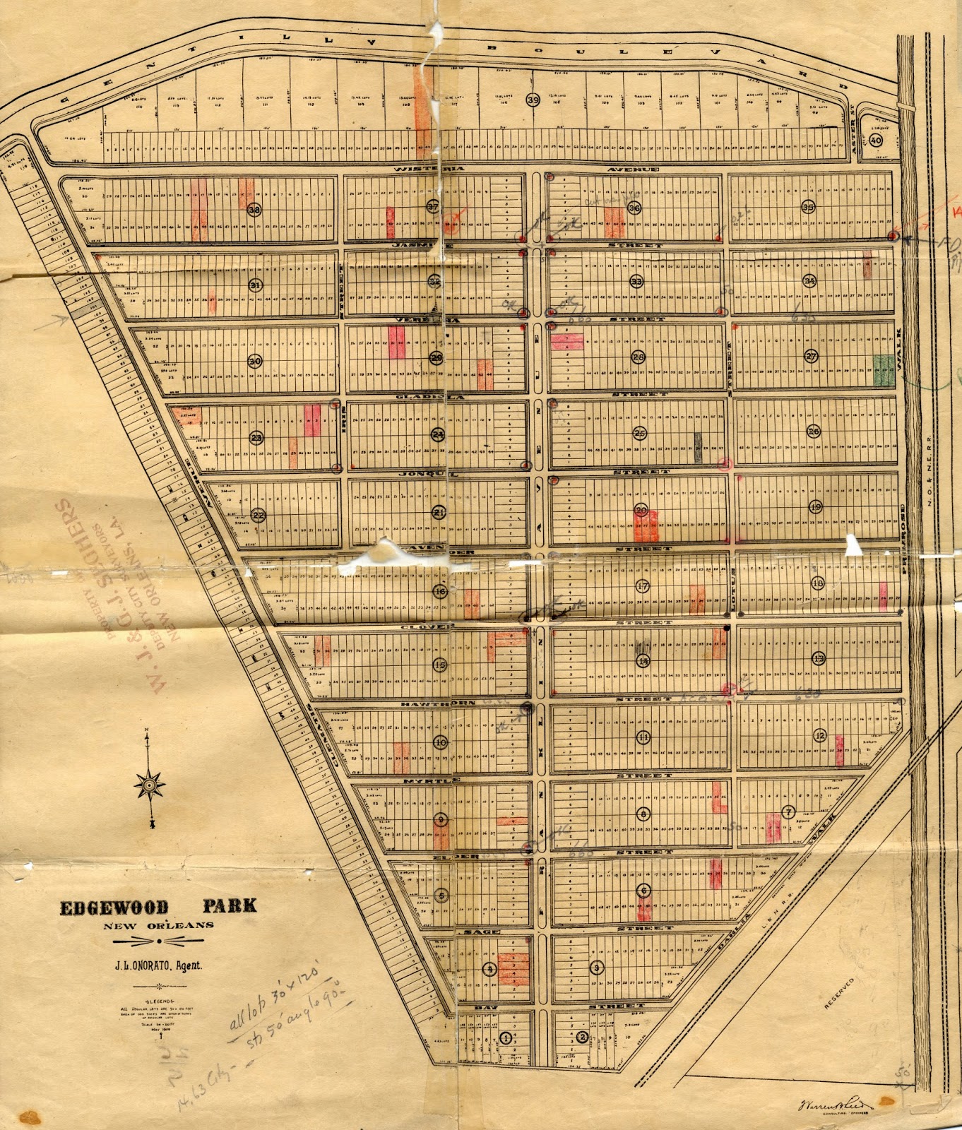
Edgewood Park

This fall the National Park Service approved New Orleans' Edgewood Park neighborhood's inclusion on the National Register of Historic Places. The subdivision was developed in 1909 on the former Dennis Sheen Tract, originally bounded by the Louisville & Nashville Railroad, the New Orleans and Northeastern Railroad, Gentilly Boulevard and Clematis Avenue. This tract was desirable pasture land covered in blackberry bushes and grass, located along a natural ridge. Real estate developer J.L. Onorato secured an option on the property in February 1909. The following month, the New Orleans Railway Company announced it would extend its Villere streetcar line a mile beyond the Franklin Avenue/Galvez Street stop in order to provide service. Soon thereafter, consulting engineer Warren B. Reed platted the subdivision with all lots measuring 30' x 120'.  Early purchasers had a tendency to buy two adjacent lots (map above). By spring of 1910, Onorato sold a large number of Edgewood's remaining lots to Grover & Leyman, an Indianapolis-based real estate investment firm.

The neighborhood includes a large number of bungalows.

Image above: William Reed, consulting engineer. Edgewood Park, New Orleans. /J.L. Onorato, Agent. May 1909. Guy Seghers Office Records, Southeastern Architectural Archive, Special Collections Division, Tulane University Libraries.

Wednesday, October 22, 2014

NOLA Benchmarks

In 1910, the New Orleans Sewerage and Water Board established a new system of permanent benchmarks that replaced a temporary one. The older system had consisted of 6" galvanized iron boat spikes driven horizontally into the city's trees at a height 30" above the ground. This system proved perishable and the board decided to establish permanent benches consisting of granite monuments weighing approximately 200 pounds that were set into larger blocks of concrete.

Assistant engineer C.B. Adams spearheaded the modernization, selecting sites in public squares, major thoroughfares and parks. All elevations indicated on the benchmarks referenced Cairo Datum taken from the old Metairie Ridge Stone, which had been set in 1869 on the lake side of the Rampart Street neutral ground on the lower side of Canal Street.

New Orleans surveyor Guy Seghers retained the board's publication, Pocket Edition of System of Permanent Bench Marks for the City of New Orleans (31 December 1910) and revised it as certain benchmarks were voided or if elevations significantly changed. Benchmark 46-B, set April 1910 in the drainage pumping station at the intersection of Florida and Jourdan Avenues, originally recorded an elevation of 24.217, but Seghers noted a corrected elevation of 22.55.

Seghers' Pocket Edition includes a complete inventory of all the 1910 benchmarks, as well as a locator map.


Map and Regulation Bench Mark above from:  Pocket Edition of System of Permanent Bench Marks for the City of New Orleans (31 December 1910). New Orleans: Sewerage and Water Board, 1910. Southeastern Architectural Archive, Special Collections Division, Tulane University Libraries.


Friday, September 26, 2014

NOLA at the Crossroads

In 1924, Highways 1, 2, 12 and 54 were starting to converge on New Orleans. The Mississippi River Scenic Highway, Jefferson Highway, the Old Spanish Trail  and the Jefferson Davis Highway represented the significant efforts of automobile boosters, government leaders and civic organizations to bring good roads into the Crescent City. Frequent rainfall and flooding often impeded visitors' abilities to enter the city by automobile.

In the early 1920s, photographer Mary Crehore Bedell and her physicist-husband Frederick took an arduous 12,000-mile road camping trip to encircle the United States. She documented the adventure in her book, Modern Gypsies (Brentano's, 1924).  Hoping to visit friends in New Orleans, the Bedells learned that the road from coastal Mississippi to New Orleans was mired in mud, as were roads along the Mississippi River to  the North. They opted to store their Hupmobile and took a train into New Orleans.


Images above:  Top:  Details. Rand McNally Junior Auto Trails Map: Louisiana. F-23 from Rand McNally Commercial Atlas of America (1924).

Bottom:  J.P. Troy, photographer. Mary Crehore and Frederick Bedell in Their Hupmobile. From Mary Crehore Bedell. Modern Gypsies. New York: Brentano's, 1924.

Wednesday, September 17, 2014

Planning New Orleans

As the New Orleans City Planning Commission and City Council consider revising the municipal zoning ordinance for the first time in 44 years, it reminded us to post these images from the mid-twentieth century. There was definitely a code book for representing urban planning; typically planners appear standing in front of a large municipal wall map while they gesticulate down towards a table map.  While the wall map usually represents the city at the macro level, the table map represents the specific area(s) undergoing transformation.

In the top image, which was published by the American Institute of Architects-New Orleans Chapter in January 1954, planners J.B. Rouzie (left) and Louis G. Bisso (right), point towards the Lakefront Airport area, located in the Third Municipal District. Bisso, then the director-secretary of the City Planning and Zoning Commission, advocated for "comprehensive rehabilitation" of neighborhoods and the discontinuation of "checkerboard" planning:

"In these days when the word 'planner' seems to be associated in some quarters with oppressive control and general loss of freedom, I believe we should never forego an opportunity to assert a rational point of view. Design must precede construction. A general design for the city must precede specific designs for improvements. I am not alone in believing that a general design for the future can be achieved in American cities, that such a design will be followed with relatively few deviations, and that its substantive effect will be a vast improvement in the conditions of life for our future population."(1)

After 22 years with the Commission, Bisso resigned in the late 1950s. Charles F. O'Doniel, Jr. (bottom image, center) filled the vacancy. Mayor "Chep" Morrison's 1958-59 report featured this picture above the caption, "THE SHAPE OF THINGS TO COME." O'Doniel stands with his chief assistants, Jack Different (left) and Stuart H. Brehm, Jr. (right) , directing his attention towards the Second Municipal District. In 1958, the Commission processed nearly 40 zoning petitions for changes in zoning classification and reviewed or acted upon nearly 300 subdivision proposals. It adopted a street plan for the area of the city bounded by Paris Road, Lake Pontchartrain and the Intercoastal Canal, and it began to consider the proposal to build a $40 million elevated expressway through the French Quarter.

Images above:

Top:  "Planners at Work." The American Institute of Architects - New Orleans Chapter Bulletin I:1 (January 1954): p. 1.

Bottom:  "THE SHAPE OF THINGS TO COME." Annual Report of the Mayor. City of New Orleans. 1958-1959: n.p.

(1) "City Planning Philosophy Outlined by Official." The American Institute of Architects - New Orleans Chapter Bulletin I:1 (January 1954): pp. 1, 4, 7.


Friday, September 5, 2014

Lost Airline Highway

Tulane University Libraries' Louisiana Research Collection, located in Joseph Merrick Jones Hall 202, has an incredible ephemera collection that includes regional maps. In order to search the files, simply go here.

The above perspective was located in the file labelled "Highways. Airline Highway" and comes from an undated promotional brochure. Courtesy Louisiana Research Collection, Special Collections Division, Tulane University Libraries.

Wednesday, July 30, 2014

New Orleans=Number One

Last  year we posted information about New Orleans architect Thomas Sully's suggestion for filling Lake Pontchartrain.

We recently came across a 1966 proposal for reducing the Mississippi River from the Garden District to the Industrial Canal. Engineer Simeon O. Coxe, Jr. of B.M. Dornblatt & Associates developed the ambitious plan as a means of "eliminating all the physical barriers preventing the progress of New Orleans towards the goal of becoming NEW ORLEANS = NUMBER ONE."

Coxe's land reclamation bid centered on the Mississippi River rather than Lake Pontchartrain, in the interest of creating 2,000 acres of real estate development sites. He felt that dredging a new Mississippi River channel from the River Bend towards the Gulf of Mexico would obviate the need for levees, railroads and warehouse buildings from Napoleon Avenue to the Ninth Ward. The area could then be utilized for modern hotels, apartment buildings, office buildings and parkways.

Coxe supported the restoration of the New Orleans riverfront circa 1790.  By blocking much of the Mississippi, he felt that the river could be brought to sea level along Jackson Square, and that a proposed Riverfront Expressway could be built along the Algiers side.

To read more, see:  "Directions." Vieux Carre Courier 3:26 (11 November 1966), pp. 4-5. Louisiana Research Collection, Special Collections Division, Tulane University Libraries.

Friday, June 20, 2014

Mapping Merriment

In the early 1950s, New Orleans illustrator Beverley Verdier designed a number of promotional materials for the Chamber of Commerce. One of her posters was utilized in travel agency and steamship offices,(1) and her similarly designed brochure was circulated to the 1959 American Institute of Architects national conference attendees, including Walter Gropius. Tulane University, cocktails, jazz and burlesque shows featured prominently in her colorful design.


(1)"Travel Posters Good." The Times-Picayune (22 August 1954): p. 32.

Image above:  Beverley Verdier. "A Map of Merriment and Opportunity." New Orleans: The City You'll Never Forget. New Orleans: Chamber of Commerce, c. 1953-54.

Monday, January 6, 2014

Cartographic Records

For those who are interested in learning more about the cartographic holdings of the Southeastern Architectural Archive, you may want to consult this recent article in Cartographic Perspectives.

Image above: Louis Bringier, surveyor. Plan of the Gurlie Property Divided into Lots Situated between Bayou Road and Canal Carondelet.  30 July 1836. [Detail]  Second District (Oversized). Guy Seghers Office Records, Southeastern Architectural Archive, Special Collections Division, Tulane University Libraries.

Thursday, April 11, 2013

NOLA Canals 1903

In 1903, engineeres Coleman, Malochee and Villere surveyed landholdings of the New Orleans Land Company between City Park Avenue and Lake Pontchartrain. They recorded the canals that punctuated the subdivision, as well as the historic tracts that formed the basis of the company's possessions. Much of this area had been utilized by charitable groups, including the Firemen's Charitable Association and the Milne Asylums. Spanish Fort is discernible in the upper right-hand corner of the map.

Image above: Coleman, Malochee and Villere. Map showing some lands belonging to the New-Orleans Land Co. situated in New-Orleans. April 1903. Martin Shepard Office Records, Southeastern Architectural Archive, Special Collections Division, Tulane University Libraries.

Friday, September 21, 2012

Frenchtown 1911

We recently came across an early article by New Orleans architect, educator, librarian and preservationist Nathaniel Cortlandt Curtis, Sr. (1881-1953). The work was one of the first to posit a "Creole architecture" in New Orleans based on social customs and climate. As a young architect, Curtis dichotomized the demands for structural integrity and "orderliness" against the artistic romanticism evoked by the city's oldest (and rotted) buildings:

"[The architect] cannot translate its decayed beauty into new and fresh materials; and even when he tries to preserve some of the antique character of the building, the result is almost certain to be inharmonious and offensive to his own artistic sense."

Image above: N.C. Curtis, "Map of the Older Section of New Orleans, Locally Known as 'Frenchtown'." In "The Creole Architecture of the Old South." The Architectural Record XLIII:5 (May 1918): p. 437.

Thursday, March 15, 2012

Hard Times 1929


As I have been processing surveyors' records associated with the development of Kenner, Louisiana, I came across a blueprint copy of S.P. Lafaye's 1925 map of the Pailet Subdivision.  The plat conveys the projected street and lot divisions, six canals, and the names of various tract owners.

But it was the verso that attracted my attention, a handwritten note dated less than a week after "Black Tuesday," 29 October 1929.  The inscription reads, "Philip Johnson/Jackson St. & High Way Kenner/Will work 10 acres across canal/where Ames Williams shack/burned down free 1st year/after that $7.00 per acre a year."

Images above from S.P. Lafaye, draftsman.  Projected Plan of Pailet-Subdivision-Pailet/In Rear of The City of Kenner, LA.  New Orleans, La:  15 May 1925.  Guy Seghers Office Records, "City of Kenner, Jefferson Parish (East), Southeastern Architectural Archive, Special Collections Division, Tulane University Libraries.

Friday, June 18, 2010

22 June 2010 NOLA PUBLIC MEETING

New Orleans City Planning Commission
Master Plan Public Hearing

Tuesday, 22 June 2010 - City Council Chambers

On June 22, 2010, the New Orleans City Planning Commission will hold a public hearing to consider the City Council's recommended revisions to the Master Plan (Motion M-10-186). The public hearing will take place in the City Council Chambers, 1300 Perdido Street, 15 minutes following the City Planning Commission's regular public meeting, which begins at 1:30pm.

Requests for further information on the agenda should be directed to the City Planning Commission Office at 504-658-7033.