The Association of Commerce News Bulletin is a good source for construction announcements dating from 1919-1972. Issues regularly feature a "New Orleans Is Growing" column that itemizes business developments and urban planning initiatives.
In September 1937, the bulletin highlighted the razing of the city's Chinatown:
"Tulane-Crescent Parking Company will start demolition of the old Chinatown area, Tulane Avenue between Rampart and Elk Place, September 15. The area will be converted into a parking lot by October 15."
The same issue nodded to Charles B. Walgreen's intent to demolish the Canal Street Beer Building in order to build a $2,000,000 drug store.
Showing posts with label New Orleans. Show all posts
Showing posts with label New Orleans. Show all posts
Wednesday, December 2, 2015

Monday, November 16, 2015
NOLA Street Dogs
We recently came across the tale of two famous New Orleans street dogs, Mike and Boozer. One hung around the Central Business District, the other habituated the French Quarter. In May 1914, Home and Country's traveling correspondent wrote:
"Down on St. Charles street, just a little distance from Canal, we will find 'Mike.' Everybody speaks of Mike when they pass him, although he is an old white dog brought to New Orleans on board an ocean liner as a special guest of the Captain, some years ago. Mike was born in London some twenty-three years ago, and has visited every port in the world.(1) To every cheery 'good morning' or 'good evening' of the passerby, Mike responds with a thump of his stubby tail on the sidewalk, a blink of one of his bleared [sic], old eyes or a nod of his battle-scarred head in much the same manner as a centenarian to whom the world is bound to show respect. We will get better acquainted with Mike some of these days. Maybe he will tell us some stories of how strange seaports appear to a dog. In the 'vieux carre' we will have to visit 'Boozer.' At one time 'Boozer' was appropriately named, for he drank not less than fourteen strong milk punches every day. Then, like a lot of other good fellows, he commenced to miss a good many of his old pals among the men who visited his master, and he began to feel strange and out of sorts. The change in 'Boozer' was so marked, that the doctor was called in and the whole trouble was laid to the door of the milk punches. As a result 'Boozer' went to the whiskey cure. He stayed there for twenty-eight days and came back a total abstainer. Next to Mike, he is perhaps the best known canine character in New Orleans. There are two factions in the city each of which will insist that one dog or the other is entitled to the medal; Mike, owing to the fact that he is the only dog in New Orleans to have been arrested and kept in a cell for fifteen days like a human, convicted of disorderly conduct; and 'Boozer,' because he is the only dog in the country to have taken the whiskey cure."(2)
If you are now wondering whether this story is a bunch of hogwash, you may be interested in a little more background information.
Mike was a favorite of the Central Business District, friend to the NOFD, saloon owners and countless messenger boys. His haunts included St. Charles and Perdido Streets. His early years in New Orleans were spent at the Klaw and Erlanger Theatres; he later circulated with the American District Telegraph runners. When a late life attack rendered him incapacitated, the Society for the Prevention of Cruelty to Animals administered strychnine and he was buried in an unmarked grave.(3)
Boozer was a French Quarter regular, adopted by J.J. Brauning, proprietor of the Greenwall Cafe at Dauphine and Iberville Streets. Boozer had arrived in New Orleans as a puppy, in the company of New York tourists who decided they could not care for him and subsequently passed him on to Brauning. When automobiles began to appear in the section, Boozer adopted a fondness for hitch-hiking. When the dog's health began to decline dramatically, Brauning took Boozer to a Burgundy Street veterinarian who offered to administer the so-called "Keeley Cure." When Boozer died in May 1915, Brauning buried him and marked the Dauphine Street grave with a marble slab.(4)
BTW, Tulane University Libraries maintain important book collections named for former New Orleanians Charlee Lachatte and Little Awful Annie.
(1)Some claimed his origins to be a Third Ward saloon.
(2)"Rambling around the 'Vieux Carre' and the New New Orleans." Home and Country X:8 (May 1914): 5-31, 31.
(3)"Mike, Most Famous Dog in New Orleans, Leaves His Beaten Paths to Meet Death." The Times-Picayune 26 May 1914.
(4)"Boozer Fills New-Made Grave Found in Dauphine Street." The Times-Picayune 9 August 1916.
"Down on St. Charles street, just a little distance from Canal, we will find 'Mike.' Everybody speaks of Mike when they pass him, although he is an old white dog brought to New Orleans on board an ocean liner as a special guest of the Captain, some years ago. Mike was born in London some twenty-three years ago, and has visited every port in the world.(1) To every cheery 'good morning' or 'good evening' of the passerby, Mike responds with a thump of his stubby tail on the sidewalk, a blink of one of his bleared [sic], old eyes or a nod of his battle-scarred head in much the same manner as a centenarian to whom the world is bound to show respect. We will get better acquainted with Mike some of these days. Maybe he will tell us some stories of how strange seaports appear to a dog. In the 'vieux carre' we will have to visit 'Boozer.' At one time 'Boozer' was appropriately named, for he drank not less than fourteen strong milk punches every day. Then, like a lot of other good fellows, he commenced to miss a good many of his old pals among the men who visited his master, and he began to feel strange and out of sorts. The change in 'Boozer' was so marked, that the doctor was called in and the whole trouble was laid to the door of the milk punches. As a result 'Boozer' went to the whiskey cure. He stayed there for twenty-eight days and came back a total abstainer. Next to Mike, he is perhaps the best known canine character in New Orleans. There are two factions in the city each of which will insist that one dog or the other is entitled to the medal; Mike, owing to the fact that he is the only dog in New Orleans to have been arrested and kept in a cell for fifteen days like a human, convicted of disorderly conduct; and 'Boozer,' because he is the only dog in the country to have taken the whiskey cure."(2)
If you are now wondering whether this story is a bunch of hogwash, you may be interested in a little more background information.
Mike was a favorite of the Central Business District, friend to the NOFD, saloon owners and countless messenger boys. His haunts included St. Charles and Perdido Streets. His early years in New Orleans were spent at the Klaw and Erlanger Theatres; he later circulated with the American District Telegraph runners. When a late life attack rendered him incapacitated, the Society for the Prevention of Cruelty to Animals administered strychnine and he was buried in an unmarked grave.(3)
Boozer was a French Quarter regular, adopted by J.J. Brauning, proprietor of the Greenwall Cafe at Dauphine and Iberville Streets. Boozer had arrived in New Orleans as a puppy, in the company of New York tourists who decided they could not care for him and subsequently passed him on to Brauning. When automobiles began to appear in the section, Boozer adopted a fondness for hitch-hiking. When the dog's health began to decline dramatically, Brauning took Boozer to a Burgundy Street veterinarian who offered to administer the so-called "Keeley Cure." When Boozer died in May 1915, Brauning buried him and marked the Dauphine Street grave with a marble slab.(4)
BTW, Tulane University Libraries maintain important book collections named for former New Orleanians Charlee Lachatte and Little Awful Annie.
(1)Some claimed his origins to be a Third Ward saloon.
(2)"Rambling around the 'Vieux Carre' and the New New Orleans." Home and Country X:8 (May 1914): 5-31, 31.
(3)"Mike, Most Famous Dog in New Orleans, Leaves His Beaten Paths to Meet Death." The Times-Picayune 26 May 1914.
(4)"Boozer Fills New-Made Grave Found in Dauphine Street." The Times-Picayune 9 August 1916.
Friday, November 6, 2015
New Orleans Brewing (1893)


By 1901, the Crescent and the Southern were both closed and Chicago brewing concerns were interested in absorbing the remaining plants.(1)
(1)"An Attempt to Absorb the Local Breweries." The Daily Picayune 26 June 1901.
Images above: New Orleans Brewing Association. World's Fair 1893: Exhibit of the New Orleans Brewing Ass'n at Chicago. New Orleans: 1893. Architectural Trade Catalogs, Southeastern Architectural Archive, Special Collections Division, Tulane University Libraries.
Thursday, October 8, 2015
New Orleans at Sea


The brochure includes Scottish interior designer John Heaney's room arrangements for the Del Norte, Del Sud and Del Mar (shown above). Passenger staterooms were commodious, and the promenade deck included wedge-shaped variants. Passengers stored clothing and other personal belongings in lockers, but Delta advised that ships in port of call would have many visitors on board, and thus recommended storing valuables with the bursar. For those interested in making new purchases, Maison Blanche department store maintained shops on all three ships.
The air-conditioned "Dels" sailed from New Orleans with stops in Rio de Janiero, Santos, Montevideo and Buenos Aires. The line served southern cuisine in its dining rooms and allowed passengers to develop their own entertainment activities. Cruise directors also orchestrated elaborate festivals, including two-day "Neptune Parties":
"On the eve of crossing the equator, the ship is boarded by Davy Jones, scribe of the Royal Court of King Neptune, accompanied by the royal prosecutor and defense attorney. The initiates who have never before crossed the equator are charged with all manner of crimes.
"On the day of crossing, King Neptune comes aboard to hold court, pass sentence upon the initiates and carry out the royal punishment. King Neptune and his Royal Court are selected from those passengers who have previously crossed the equator. The initiates are awarded a handsome certificate, signed by Davy Jones."(1)
When docked at New Orleans' Poydras Street wharf, the boats became entertainment venues for such groups as the National Coffee Association and the Associated Press Managing Editors' Association. Fashion and jewelry shows, international trade events and awards celebrations became quite popular on the Dels.
(1)"Planned Recreation Keynotes Delta Luxury Line Voyages." The Times-Picayune 4 November 1949.
Images above: George G. Sharp, architect; John Heaney, interior designer. "Main Deck" and "Promenade Deck." from Delta Line Information and Rate Schedule. South America-West Africa. No. 10. New Orleans?: Delta Lines, 1956. Southeastern Architectural Archive, Special Collections Division, Tulane University Libraries.
Tuesday, September 29, 2015
100 Years Ago


The Southeastern Architectural Archive has been in the process of digitizing a number of glass plate negatives that document the hurricane's aftermath. The images are most likely the work of photographer John Norris Teunisson (1869-1959). The plates were once acquired by New Orleans architect Richard Koch. Stored in large wooden boxes, some were broken, all were in deteriorated condition.
Zachary Wubben, a Tulane undergraduate working on the project, is currently developing metadata for the images, as most were unidentified or partially identified. The SEAA plans to launch a new digital collection featuring the images in the near future.
If you want to read more about the hurricane from a contemporary source, consult Sewerage and Water Board of New Orleans General Superintendent George G. Earl's October 14 1915 report here, made available by the University of Chicago.
Images above: John N. Teunisson, attributed. 1915 Hurricane, New Orleans, LA. 1915. Digital surrogates from glass negatives created 2015. Richard Koch Photographs and Papers, Southeastern Architectural Archive, Special Collections Division, Tulane University Libraries.
Wednesday, September 23, 2015
Underneath

During the 1930s, there was considerable interest in collecting and compiling information related to the geology of New Orleans. Local engineers had long advocated the need for a comprehensive assessment, but it was not until President Franklin Delano Roosevelt created the Works Progress Administration (WPA) that Louisiana had the requisite funds. The State Board of Engineers endorsed and sponsored WPA projects to document soil and foundations, and to develop accurate elevation datum.
The WPA created the Louisiana Geodetic Survey’s Precise Elevations: City of New Orleans (1937) to record modern datum planes. Prior assessments had been generated by various federal, state and municipal government entities for their own purposes. These data sets proved divergent and did not reflect ground surface settlement changes resulting from early twentieth-century drainage modifications. Precise Elevations set the new WPA datum planes (measured in 1935), compared against the historic data compiled by the Dock Board, the Levee Board, the Sewerage and Water Board, and the United States (Army) Engineering Department.
The WPA’s survey Some Data in Regard to Foundations (1937) was a comprehensive assessment of the variable soil conditions underlying New Orleans, and their effects on historic and contemporary construction. WPA researchers spent two years consulting public and private records, and soliciting anecdotal and illustrative documentation from architects, engineers and builders. They gathered cartographic records, foundation plans, stratigraphic and piling data to chronicle historic construction methods aimed at tackling the city’s alluvial soils. In the process, they measured and rendered the city’s notable structures, including the American Bank Building, the Lakefront (formerly Shushan) Airport, and the U.S. Marine Hospital complex.
The WPA also documented such works as the Robert E. Lee Monument located in Lee Circle at the intersection of St. Charles Street and Howard Avenue. Alexander Doyle (1857-1922) and Confederate veteran John Roy designed the monument, which was unveiled 22 February 1884. The WPA estimated that the monument weighed a total of 1,141 tons which was dispersed to its 81 untreated, unpeeled red cypress piles (detail above). Excavation work conducted in 1929 revealed that over half of the piles' lengths (varying from 40-49' feet) were situated below the water line.

Friday, August 21, 2015
Beautiful Levee (August 1845)
170 years ago, the Mississippi Free Trader and Natchez Gazette reported on improvements to New Orleans' water management system. The city's First Municipal District had expended resources towards its levee and streets:
"The First Municipality is vigorously engaged, now that she is clear of debt, in making her Levee the most beautiful in the city, and repairing her streets in splendid style. As she is bounded in front by her two enterprising sister Municipalities, she has commenced draining her swamps in the [illegible] on a grand scale and will reclaim a [great?] territory from the dreary home of the craw-fish and the aligator [sic]. The ancient heart of the city will hereafter extend her streets to the Metairie Ridge and to Lake Pontchartrain."
Mississippi Free Trader and Natchez Gazette 12 August 1845; Issue 95. As viewed via 19th Century U.S. Newspapers, 21 August 2015.
"The First Municipality is vigorously engaged, now that she is clear of debt, in making her Levee the most beautiful in the city, and repairing her streets in splendid style. As she is bounded in front by her two enterprising sister Municipalities, she has commenced draining her swamps in the [illegible] on a grand scale and will reclaim a [great?] territory from the dreary home of the craw-fish and the aligator [sic]. The ancient heart of the city will hereafter extend her streets to the Metairie Ridge and to Lake Pontchartrain."
Mississippi Free Trader and Natchez Gazette 12 August 1845; Issue 95. As viewed via 19th Century U.S. Newspapers, 21 August 2015.
Thursday, September 18, 2014
NEW! N.C. Curtis Finding Aid
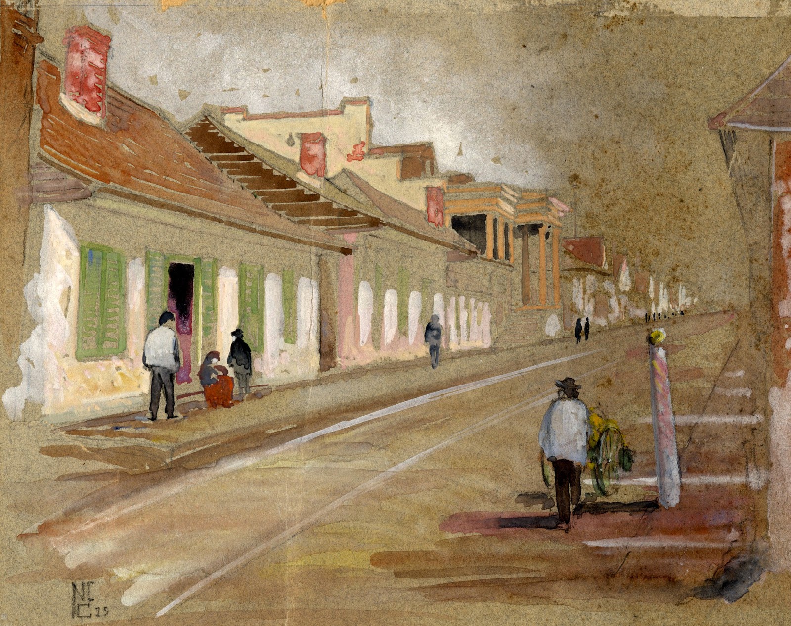
Learn more about the collection and N.C. Curtis here.
Image above: Nathaniel C. Curtis, Sr. Dauphine Street from St. Louis Street. Gouache on heavy paper. 1925. Nathaniel C. Curtis, Sr. Illustrations, Southeastern Architectural Archive, Special Collections Division, Tulane University Libraries.
Wednesday, September 17, 2014
Planning New Orleans


In the top image, which was published by the American Institute of Architects-New Orleans Chapter in January 1954, planners J.B. Rouzie (left) and Louis G. Bisso (right), point towards the Lakefront Airport area, located in the Third Municipal District. Bisso, then the director-secretary of the City Planning and Zoning Commission, advocated for "comprehensive rehabilitation" of neighborhoods and the discontinuation of "checkerboard" planning:
"In these days when the word 'planner' seems to be associated in some quarters with oppressive control and general loss of freedom, I believe we should never forego an opportunity to assert a rational point of view. Design must precede construction. A general design for the city must precede specific designs for improvements. I am not alone in believing that a general design for the future can be achieved in American cities, that such a design will be followed with relatively few deviations, and that its substantive effect will be a vast improvement in the conditions of life for our future population."(1)
After 22 years with the Commission, Bisso resigned in the late 1950s. Charles F. O'Doniel, Jr. (bottom image, center) filled the vacancy. Mayor "Chep" Morrison's 1958-59 report featured this picture above the caption, "THE SHAPE OF THINGS TO COME." O'Doniel stands with his chief assistants, Jack Different (left) and Stuart H. Brehm, Jr. (right) , directing his attention towards the Second Municipal District. In 1958, the Commission processed nearly 40 zoning petitions for changes in zoning classification and reviewed or acted upon nearly 300 subdivision proposals. It adopted a street plan for the area of the city bounded by Paris Road, Lake Pontchartrain and the Intercoastal Canal, and it began to consider the proposal to build a $40 million elevated expressway through the French Quarter.
Images above:
Top: "Planners at Work." The American Institute of Architects - New Orleans Chapter Bulletin I:1 (January 1954): p. 1.
Bottom: "THE SHAPE OF THINGS TO COME." Annual Report of the Mayor. City of New Orleans. 1958-1959: n.p.
(1) "City Planning Philosophy Outlined by Official." The American Institute of Architects - New Orleans Chapter Bulletin I:1 (January 1954): pp. 1, 4, 7.
Friday, June 20, 2014
Mapping Merriment

(1)"Travel Posters Good." The Times-Picayune (22 August 1954): p. 32.
Image above: Beverley Verdier. "A Map of Merriment and Opportunity." New Orleans: The City You'll Never Forget. New Orleans: Chamber of Commerce, c. 1953-54.
Monday, December 16, 2013
"Seasonal Will & Changing Moods"

"It has been objected that New Orleans 'has too much water' at her doors. The Inner Harbor-Navigation Canal Marks the beginning of the putting to use of this water in a scientific way, a proper placing and control of it, instead of as heretofore being subject to uncontrollable seasonal will and changing moods. Conservation at its best!
"When completed, this canal will rank with the half-dozen greater world canals -- only three now existing having a depth as great as the New Orleans undertaking -- the Panama, Suez and Kiel. Depth of sill-clearance of the locks is a test of the canal's greatness and importance -- the New Orleans lock will have 30 feet over the sill. It is by far the single greatest factor of port development yet undertaken by the Port Commissioners of New Orleans, and the engineering study of its economic factor destines it to be one of the nation's great and most highly co-ordinated industrial regions of the future, with every facility of modern commerce, transport by rail, river, canal, lake and ocean; for raw and finished product; banking facilities and a location in the heart of the South's greatest labor market."
The triplet buildings (4400 Dauphine Street) in the foreground space were completed under the direction of the U.S. Army Quartermaster Corps in 1919. The Board of Commissioners, Port of New Orleans, leased two of the buildings after World War I. The Board also subleased spaces to individual commercial ventures. The property reverted to the U.S. War Department during World War II and the name of the complex was changed to the New Orleans Port of Embarkation. After the war, the structures were known as the New Orleans Army Terminal, and in 1966 the Navy assumed custody, renaming them as the Naval Support Activity. In 1973, administrative changes within the Navy resulted in significant alterations to the exterior and the surrounding site. These were undertaken by associated architects Waldemar S. Nelson; Nolan, Holcombe, Apatini & Seghers; Nolan, Norman & Nolan; James P. Oubre and August Perez & Associates. On 3 July 1975, the buildings were dedicated as the F. Edward Hebert Defense Complex. In October 2013, the City of New Orleans acquired the complex.
Morgan D.E. Hite, editor. "Details of Construction." Building Review (August 1918): pp. 20-21. Louisiana Research Collection, Special Collections Division, Tulane University Libraries.
See also: "Dedication Ceremony: F. Edward Hebert Defense Complex." Brochure. 1975. Project No. 1279. William T. Nolan Office Records, Southeastern Architectural Archive, Special Collections Division, Tulane University Libraries.
Thursday, October 17, 2013
Street Cars & Population Growth

"Perhaps the most striking effects a street car line can have on the distribution of population is shown in the extension of the Villere line by the Edgewood Addition and Gentilly Terrace. This line was only prolonged to take in these spots in 1910, yet within the short period intervening between then and now there has been built up the first true suburb to the city, excluding the Lakeview property."(1)
Early twentieth-century streetcar expansions included the development of the Louisiana Avenue and Audubon Boulevard lines. Since property values along the Carrollton Avenue and Clio Street lines had significantly increased, investors flocked to purchase lots along the proposed new corridors.(2) The Louisiana Avenue line was viewed as especially promising for real estate development, since the route offered a direct link between mercantile Canal Street and Harvey Canal industries.
Image above: Unidentified photographer. New Orleans Railway & Light Company Streetcars. 14 July 1913. Miscellaneous Photographs Collection, Southeastern Architectural Archive, Special Collections Division, Tulane University Libraries.
(1)R.P. Porter. "Street Cars and the Movement of Population in New Orleans." The Daily Picayune (26 October 1913): p. 33.
(2)See, for example certain records in the Martin Shepard Office Records & Guy Seghers Office Records, Southeastern Architectural Archive, Special Collections Division, Tulane University Libraries.
Wednesday, June 12, 2013
2517-2519 Columbus Street


The two-story weatherboard building was intended to function as a school annex, accommodating restrooms, additional classrooms, an auditorium and a cafeteria. Reverend Janssens contributed personal funds towards the building, as he had with earlier parish building projects.(1)
The Southeastern Architectural Archive retains plans for all three St. Rose of Lima structures, as well as block plans for the properties the parish acquired. The Louisiana Research Collection has additional holdings relevant to the church that have been described in the department blog.
(1)Roger Baudier, Sr. Centennial/St. Rose of Lima Parish/New Orleans, LA. New Orleans: 1957, p. 56. Louisiana Research Collection, Special Collections Division, Tulane University Libraries.
Images above: Andry & Feitel, architects. Raised Frame Parochial School Building for St. Rose de Lima Parish. [2517-2519 Columbus Street] 30 June 1938; Revised 7 July 1938. Andry & Feitel Office Records, Southeastern Architectural Archive, Special Collections Division, Tulane University Libraries.
Thursday, June 6, 2013
DIY French Quarter Walking Tour

Map for a Promenade through the Historic Vieux Carre of New Orleans. Undated map. Frank H. Boatner Collection of Louisiana Architecture Photographs, Southeastern Architectural Archive, Special Collections Division, Tulane University Libraries.
Friday, May 17, 2013
Consulates in New Orleans 1964
In 1964, the city of New Orleans paid honor to the members of the New Orleans Consular Corps and their "Ladies." The International Relations Office of the City of New Orleans, then located in Rathbone DeBuys' International Trade Mart (#1), was the liaison office for the consular corps and arranged an event program that included an art exhibit and a performance by the New Orleans Recreation Department Civic Orchestra.
There were 41 consulates in New Orleans at the time:
Argentina
Austria
Belgium
Bolivia
Brazil
Canada
Chile
Colombia
Costa Rica
Denmark
Dominican Republic
Ecuador
El Salvador
Finland
France
Germany
Great Britain
Greece
Guatemala
Haiti
Honduras
Italy
Japan
Liberia
Mexico
Monaco
Netherlands
Nicaragua
Norway
Panama
Paraguay
Peru
Philippine Republic
Portugal
South Africa
Spain
Sweden
Switzerland
Uruguay
Venezuela
Yugoslavia
By 1969, many of these consulates and others were located in Edward Durell Stone's International Trade Mart (#2), located at 2 Canal Street, shown below.
 Matt Anderson, photographer. Mississippi River from Plaza Tower, New Orleans, LA. Circa 1970. Southeastern Architectural Archive, Special Collections Division, Tulane University Libraries.
For list of consulates, see: New Orleans International Relations Office. Second Annual Reception in honour of the New Orleans Corps and Their Ladies. New Orleans: 1964. Frank H. Boatner Collection, Southeastern Architectural Archive, Special Collections Division, Tulane University Libraries.

There were 41 consulates in New Orleans at the time:
Argentina
Austria
Belgium
Bolivia
Brazil
Canada
Chile
Colombia
Costa Rica
Denmark
Dominican Republic
Ecuador
El Salvador
Finland
France
Germany
Great Britain
Greece
Guatemala
Haiti
Honduras
Italy
Japan
Liberia
Mexico
Monaco
Netherlands
Nicaragua
Norway
Panama
Paraguay
Peru
Philippine Republic
Portugal
South Africa
Spain
Sweden
Switzerland
Uruguay
Venezuela
Yugoslavia
By 1969, many of these consulates and others were located in Edward Durell Stone's International Trade Mart (#2), located at 2 Canal Street, shown below.

For list of consulates, see: New Orleans International Relations Office. Second Annual Reception in honour of the New Orleans Corps and Their Ladies. New Orleans: 1964. Frank H. Boatner Collection, Southeastern Architectural Archive, Special Collections Division, Tulane University Libraries.
Wednesday, August 4, 2010
Brookings Institute New Orleans Study
The Brookings Institute has published a new study focused on the recovery of New Orleans after Hurricane Katrina. The New Orleans Index at Five summatively assesses the community's resilience and prosperity over the five-year period since the levee breach disaster. Tulane faculty contributed to the related essay series: Karen DeSalvo (Tulane School of Medicine); Mark Davis (Tulane Institute on Water Resources Law & Policy); and Richard Campanella (Tulane Center for Bioenvironmental Research).
Subscribe to:
Posts (Atom)