Showing posts with label cemeteries. Show all posts

Tuesday, November 24, 2015

Old Marrero Cemeteries

Continuing on yesterday's theme regarding placing and dating historic cemeteries in southeastern Louisiana. . .

Civil engineer (c.e.) James Webb platted the so-called Robinson Avenue Subdivision in early 1921. He based his map on two existing plans, one that c.e. H.L. Zander developed in 1915 (reproduced above as "Exhibit A"); and one that J.W.T. Stephens created in 1919. For surveyors, crediting earlier surveys is an important part of the process: the quality of a new plat depends on the accuracy of its sources.

Zander had attempted to establish the Arpent Tract between the Southern Pacific Railroad and the new Amesville Highway.(1) Identifying the cross-axial artery as "Robinson Lane," Zander referenced the former land holdings of the Robinsons and the Dennises. He also measured two historic cemeteries, one he referred to generically and the other he identified as the St. Joseph Cemetery.

Both cemeteries appear on the Sanborn Fire Insurance Atlas of 1937, which I manipulated below. "A" is the St. Joseph Cemetery and "B" is the unnamed one.

St. Joseph Cemetery is still extant (333 Robinson Avenue) and has been expanded towards its originating worship space. Its historic neighbor is now a near-empty lot.


(1)This later became part of the Jefferson Highway, and today is referred to as Fourth Street.

Images above: Digitally enhanced detail of James Webb, c.e.. Robinson Avenue Subdivision. New Orleans: 5 May 1921. Blue line copy, from Guy Seghers Office Records, Southeastern Architectural Archive, Special Collections Division, Tulane University Libraries. Box 119. Folder 30.

Digitally altered detail of Sanborn Fire Insurance Atlas. Volume 7 [true 11]. Sheet 1119. New York: 1937. As viewed via Digital Sanborn Maps Database, available at Tulane University Libraries.

Monday, November 23, 2015

Old Harvey Cemeteries

Subdivision surveys can help researchers locate historic cemetery sites. The Southeastern Architectural Archive's Guy Seghers Office Records has a considerable number of twentieth-century surveys that document graveyard locations.

The cemetery highlighted above -- in a 1922 Eustis & Bres survey -- was located towards the rear of the Louisiana Cypress Lumber Company's tract along the Harvey Canal in Jefferson Parish. This area was formerly known as the Destrehan Tract, and Joseph Rathborne began to operate a cypress lumber concern here as early as 1889.(1)

By 1940, the Rathborne Land Company was subdividing its massive holdings along the Intracoastal Waterway. The area where the old cemetery had been was redeveloped as a residential section of four- and five-room frame residences. Surveyor Guy Seghers platted the subdivision, noting an existing cemetery along what had been Julia F. Grefer's land (shown below).

This second graveyard is still intact, known as the Evening Star Cemetery [AKA Harvey's cemetery; Harvey cemetery]. Since Hurricane Katrina, it has expanded across Grefer Avenue, absorbing what had formerly been a series of 30' wide residential lots.

Knowing variant geographical names can facilitate the research process. Consulting  GNIS is one means of determining place name changes. For Louisiana, knowing the names of subsequent plantation owners is also beneficial. Marie Adrien Persac's Norman's Chart of the Lower Mississippi River (1858) is one means of determining familial connections, and the United States Mississippi River Commission's Preliminary Map of the Lower Mississippi River: From the Mouth of the Ohio River to the Head of the Passes (1885) is another.

(1)Advertisement. The Times-Picayune 5 July 1948.

Images above: Digitally enhanced detail of Eustis & Bres. LA Cypress Lumber Co. Tract. Survey. 1922. Box 120. Folder 45.

Digitally enhanced detail of Guy J. Seghers. Industrial Subdivision of Property of Joseph Rathborne Land Company, Inc. Harvey, Louisiana. 10 October 1940 with annotated corrections to February 1944. Box 120. Folder 29.

Both Guy Seghers Office Records, Southeastern Architectural Archive, Special Collections Division, Tulane University Libraries.


Friday, November 21, 2014

William S. Wiedorn

William “Bill” Shaffrath Wiedorn (1896-1990) was a prominent landscape architect and town planner. Born in Baltimore, Maryland, he graduated from Waterbury High School (CT), and then served in the United States Army during World War I as a Second Lieutenant in the infantry division’s machine gun section. After receiving his Bachelor of Science (1919) and while completing his Master of Landscape Design (1921) degree at Cornell University, Wiedorn was a member of the Reserve Officers Training Corps (ROTC). During this period, he also worked as an assistant designer for the Olmsted Brothers in Brookline, Massachusetts. In their employ, he contributed to the development of large estate subdivisions and park design. Most notably, he devised the planting and grading of the Rolling Rock Country Club in Pittsburgh, Pennsylvania.


Image above:  William S. Wiedorn, landscape architect. New Orleans City Park Administration Building and the Climatron Area. [Detail].  George J. Riehl, chairman, Technical Advisory Committee. 16 June 1965.

Wednesday, December 4, 2013

Goodwill Industries

For those wondering about the building located at 2000 Jackson Avenue that is being demolished today (google streetview above), the structure underneath was designed by New Orleans architect Edward B. Silverstein for Goodwill Industries in 1958. His commission required the inclusion of a chapel, loading platform, terrace, kitchen, offices, a large work area and a salesroom for the nonprofit organization's job-training operations. Only the former sales and work areas lasted until 2013, and the exterior had been dramatically altered.

When Silverstein started the project in 1957, he hired surveyor F.C. Gandolfo, Jr. to review earlier surveys and develop new measurements for the existing conditions at the site.

Lot 24A was the Old Hebrew Rest Cemetery, partially bordered by a brick fence and remnants of its foundations, and dotted with "miscellaneous rubble and old tombs" and an established mulberry tree, hackberries, cedars and oleanders. Goodwill Industries acquired the site from Touro Synagogue -- which had owned the property since 1828 -- in August, 1957. The cemetery had not been used as a burial site for decades, and the New Orleans Rabbinical Council made arrangements for appropriate reinterments.

After the site was cleared, pile driving commenced on 30 October 1958. Mayor deLesseps Morrison cut the ribbon at the building's formal dedication on 24 September 1959.

Second Image:  Edward B. Silverstein, Architect. Goodwill Industries. Detail of East Elevation. 17 February 1958. Edward B. Silverstein Office Records, Southeastern Architectural Archive, Special Collections Division, Tulane University Libraries.

Third Image: F.C. Gandolfo, Jr., surveyor for Mr. Ed. Silverstein, Arch. Lot 24A Square 299 Fourth District. 20 May 1957. Edward B. Silverstein Office Records, Southeastern Architectural Archive, Special Collections Division, Tulane University Libraries.
Tuesday, March 12, 2013

NEW! Weiblen Finding Aid

The Southeastern Architectural Archive recently completed the full processing of the Albert Weiblen Marble and Granite Company Office Records. The collection consists of project drawings, photographs, sales specimens, correspondence, ledgers and indices. Highlights include drawings for the Josie Arlington tomb in Metairie Cemetery, the plaster model for the McCarthy Square Victory Arch, and a series of historic tomb images commissioned by architect Charles L. Lawhon of photographer Louis T. Fritch.

This and other SEAA finding aids may be found online here.

Image above:  “Albert Weiblen.” In W.K. Patrick & Assoc. Club Men of Louisiana in Caricature. East Aurora, NY: The Roycrofters, 1917. The Louisiana Research Collection, Special Collections Division, Tulane University Libraries.

Tuesday, February 26, 2013

Metairie Cemetery Souvenir Map

An early souvenir map  that shows the locations of the lagoons along the perimeters of Metairie Cemetery. Dug in 1890, these lagoons benefited from proximity to the New Basin Canal, from which gravity pumps diverted fresh water. Congestion problems at the intersection of Metairie and Pontchartrain Boulevards and City Park Avenue were well publicized by 1929, and by the 1950s these roadways were widened and this stretch of the New Basin Canal was filled.(1)

(1)Henri A. Gandolfo. Metairie Cemetery: An Historical Memoir. New Orleans: Stewart Enterprises, 1981 and "Pleasant Scenes on Metairie Trip" The Times-Picayune (3 November 1929): p. 1; 6.

Image above: Souvenir Map Presented to Mr. S.H. Bell by Helmuth Holtz. New Orleans: February 1904. Albert Weiblen Marble & Granite Company Office Records, Southeastern Architectural Archive, Special Collections Division, Tulane University Libraries. The SEAA retains other maps of the cemetery, from 1955; 1965; 1975; 1978.

Tuesday, January 8, 2013

Metal Caskets

In 1931, the Fuller Company, charged with site clearance for the new Louisiana State Capitol building in Baton Rouge, began to uncover human remains. When construction operations were initiated, the project architects Weiss, Dreyfous & Seiferth had been informed that there was a possibility this would happen, as certain portions of the site had once been used as a cemetery. They had the site surveyed and any bodies that were easily located were disinterred and reburied. When one of the Fuller Company steam shovel operators struck a metal casket, construction was immediately halted, and a Baton Rouge treasure hunter named George Maher, Sr. was hired to locate any other such cases using a radio device.(1)

Maher ultimately uncovered some twenty-three metallic coffins.(2)  On 11 April 1931, some of the caskets  -- now removed to a collective burial site -- were photographed as part of the construction documentation (shown above).


Such metal caskets were popular during the second half of the nineteenth century, and a host of entrepreneurs patented their own versions. Almond D. Fisk of New York famously patented the model above in November 1848. It featured a round glass window for the face that was securely mounted to the casket. Fisk suggested removing all air from the coffin in order to prevent putrefaction.
Martin Crane -- representing Crane, Breed & Company of Cincinnati -- patented this  "Metallic Coffin" in March 1855. His model featured an octagonal-shaped glass window for the face, and a name plate, both with ornamental molded surrounds. 
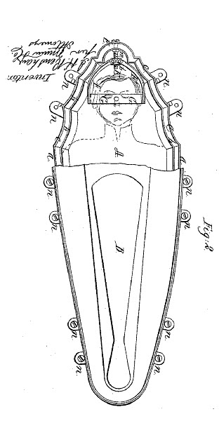
In 1861, Knoxville inventor James H. Renshaw patented this "Metallic Coffin," asserting his improvements over earlier types. He employed unique bevels along the upper edges of his caskets.
Among the patent developers, one of the most unusual descriptions accompanied Philip K. Clover's "Coffin-Torpedoes," in which he claimed his invention would prohibit the "unauthorized resurrection of dead bodies" because any attempt to remove the body after burial would cause the death of the grave robber. His patent involved the use of spring-loaded explosives.

After the Civil War, Crane, Breed & Company established a New Orleans office on Magazine Street. They advertised their services in Gardner’s New Orleans Directory for 1867.
One of Crane's competitors was T.W. Bothick, who  sold "metalic burial cases" of the type patented by Lucian Fay in 1864. These were a much simpler form, with Fay recommending the use of sheet rather than cast metal.

It's a good thing the 1931 State Capitol crew didn't encounter any of the booby-trapped torpedoes!


(1) Weiss, Dreyfous & Seiferth, Inc. Letter to Mr. Harris N. English dated 19 December 1931. Weiss, Dreyfous and Seiferth Office Records, Southeastern Architectural Archive.

(2) Gene Bylinsky. "Search for the Pot of Gold." The Times-Picayune (30 September 1956): pp. 134-135.

Images above:

Progress Photograph of Caskets Removed to Collective Burial Pit. 11 April 1931. Weiss, Dreyfous & Seiferth Office Records, Southeastern Architectural Archive.

All patent images from google patents.

"Crane, Breed & Co." Gardner’s New Orleans Directory for 1867. New Orleans, 1867. Southeastern Architectural Archive.

"T.W. Bothick, Undertaker." Gardner’s New Orleans Directory for 1867. New Orleans, 1867. Southeastern Architectural Archive.