Tuesday, December 22, 2015

Merry Travels/Holidays!

In 1939, Laura Mae Gumb of Hope, North Dakota took a long rail journey with her best friend Alice Curtis. They wanted to visit the New York World's Fair and see Washington, D.C. In the process, they celebrated the retirement of a 70-year-old Great Northern railroad engineer (above), ventured to Chinatown, and remarked on the wonders they saw. They drank cocktails at the Diamond Horseshoe and the Savoy.  They also seemingly stole a lot of restaurant menus, napkins and ashtrays. They met travelers from all over the world.

May your travels and festivities this season be equally remarkable!


Friday, December 18, 2015

New Orleans As Divine Feminine

In 1915, New Orleans bungalow architect Morgan Dudley E. Hite (1882-1959) developed a map titled "New Orleans --Center of the World" (shown above). Mayor Martin Behrman's administration liked the map so much, it was used in a full-page advertisement the following year (shown below), accompanied by the passage:

"New Orleans is not content to rest secure and apathetic in her position as the center of the world, the center of world population, the center of world-production, the center of world-navigation.

"That much was done for the City of New Orleans by Nature.

"But to supplement this handsome and generous work of Nature the City of New Orleans is building for the future when the new industrial empire at her door will have been developed; when the wet lands at her door have been reclaimed; when the cut-over pine lands will have been turned to the plow; when the natural resources of her tributary section will have been made to yield the golden tribute of their promise."(1)

(1)"The Eyes of the World Are on New Orleans." Trade Index 28:6 (June 1916); recto of back cover. Louisiana Research Collection, Special Collections Division, Tulane University Libraries.

Wednesday, December 16, 2015

New Orleans Business Archive: Friede & Goldman

The New Orleans firm of Friede and Goldman, Ltd. was established by Jerome L. Goldman (1924-2013, shown left above) and Commander Vladimir M. Von Der Friede in 1949. Friede (1895-1966) had been a Russian naval officer prior to the revolution, and joined the U.S. Navy during the Second World War. Goldman was a 1944 University of Michigan School of Naval Architecture graduate who had worked for Andrew Jackson Higgins during the war.

The partners quickly established a firm of international renown. They designed ships and offshore rigs. In 1957, they collaborated with Kaiser Aluminum and Chemical Corp. and Bryant Boats (Bayou LaBatre, AL) to introduce all-aluminum welded towboats for work in marshland oil fields.(1) Three years later, the marine engineers developed a number of new vessels for the Delta Steamship Line, including:

Del Rio (Avondale Shipyards, Inc., 1960)
Del Sol (Avondale Shipyards, Inc., 1960)
Del Oro (Avondale Shipyards, Inc., 1960)

These three ships were originally planned for Delta's West African trade routes. The S/S Del Rio was the largest vessel ever built on the Mississippi River when it launched in July 1960. Friede and Goldman departed from traditional ship design in placing the superstructures in the forward part of the ship. The "Dels" were designed for a speed of 18 knots.

After Friede retired in February 1962, Goldman continued to manage the firm. Under his direction, the company designed five new Delta cargoliners:

Delta Argentina (Ingalls Shipyard Division of Litton Industries, 1968)
Delta Brazil (Ingalls Shipyard Division of Litton Industries, 1968)
Delta Paraguay (Ingalls Shipyard Division of Litton Industries, 1968)
Delta Uruguay (Ingalls Shipyard Division of Litton Industries, 1968)
Delta Mexico (Ingalls Shipyard Division of Litton Industries, 1968)

The S/S Delta Argentina was the first to launch. The 1968 ships featured centralized control stations in the engine rooms and on the bridge, as well as "bulbous" bows that were intended to increase speed (designed for 20 knots) and economize fuel.(2)

In 1969, Goldman introduced the world's first LASH (lighter aboard ship), the M/S Acadia Forest. This new transportation system was constructed at the Equitable-Higgins Shipyards on the Industrial Canal. The Port of New Orleans became the embarkation point for modern containerization techniques.

For more maritime history see the Mariners' Museum website.

For more about Avondale Shipyards, consult the University of New Orleans' Earl K. Long Library.

(1)"Aluminum Towboat for Bayou Work Is Planned." The Times-Picayune 17 February 1957.

(2)"Delta Inc. Ship on Maiden Voyage." The Times-Picayune 20 April 1968.

Image above: Jerome L. Goldman and Avondale Shipyards exec. vice president Henry Z. Carter at the Launching of S/S Del Rio. Chamber of Commerce News Bulletin LI:29 (15 July 1960): p. 2. Louisiana Research Collection, Special Collections Division, Tulane University Libraries.

Tuesday, December 15, 2015

OST Hot Spots

Since I attended the Old Spanish Trail Centennial Celebration in Mobile, Alabama last week, I've been thinking about how the Good Roads Movement affected commercial architecture. Tracking down relevant structures requires mapping OST road beds and cross-checking Sanborn data sets, building plans and historic newspaper accounts.

The route -- highlighted above -- took westbound travelers through the Crescent City along Bayou Sauvage/Gentilly Road to North Broad  (via Paris) on to Canal, St. Charles, Broadway and ultimately to the Westwego-Walnut Street ferry.(1)

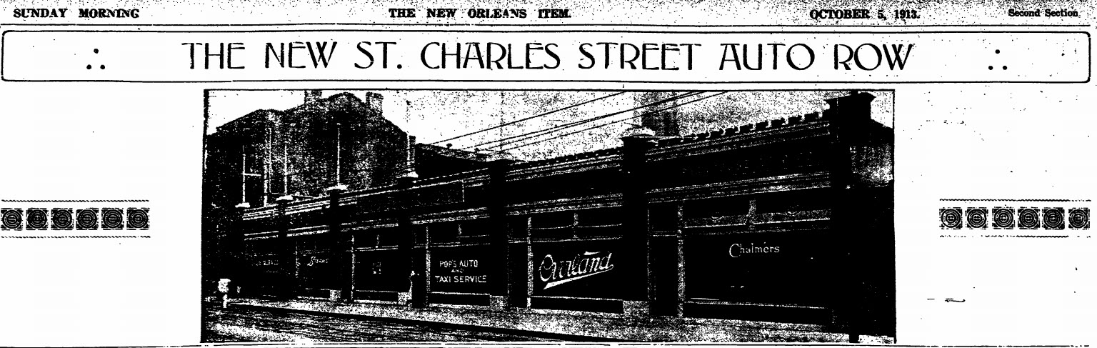
A St. Charles Street "Automobile Row" began to emerge in 1913. Various developers acquired historic residences along the artery between Girod and Julia Streets, and either adapted them or razed them for other use. Julius Koch was awarded a contract to demolish a boarding house and construct a 131' foot showroom (preliminary rendering above; photograph below). Three years later, Koch also designed a new building for the Firestone Tire and Rubber Company.(2)
Not all of the structures listed below are still standing, but most of them are. Some of them feature ornamental automobile symbolism such as wheels and wings.

If you are interested in learning more about the OST Centennial and/or wish to become involved in the planning process, click here.

St. Charles Avenue

1400

M.G. Bernin Motor Trucks (1919)

1423

Motor Car Service Company, Inc. (1920)

1701-11

Abbott Motor Company {Two buildings -- Packard Showroom & Apartments/Showrooms} (1920)

1820 

Packard New Orleans Company (1929)


2001 

Abbott Automobile Company (1920)


St. Charles Street


700

Fairchild Motor Car Company (1917)

706

Woodring-Hamilton Car Company (1916)

714

Ellis Motor Company [formerly King Motor Company] (1920)

721

United Motor Car Company (1920)

726

Safety Tire Repair Company (1916)

728

Hotel Orleans (altered for this use in 1917-1918)

734

Demack Motor Car Company (1918)

735

Herbert E. Woodward Tires (1915)

741

Capital City Auto Company (1915)

742

Moon Agency (1914)

749

L.A.M. Motor Company (1918)

750

B.F. Goodrich Company New Orleans Branch (1914)

752

Abbott Auto Company "Used Car" Department (1919)

759

Stoutz Motor Car Company (1917)

760-762

Willys-Overland Company (1914)

Firestone Tire and Rubber Company (1916)

Freeport & Mexican Fuel Oil Company (1917)

829 

Capital City Auto Company (1919)


And others that were very near to the OST:

Baronne Street

601-603

Charles E. Miller New Orleans Branch [Automobile Sales] (1910)

615-621

Shuler Auto Supply Company Inc. (1919)

618 

M. Zilberman Show Room (1918)

702-716

Abbott Cycle Company (1906)
{They also sold automobile gloves}

Abbott Automobile Company (1908)

751-761

New Orleans Chevrolet Company (1926)

801

Brown Tube Company (1914)

Model Motor Truck Company, Inc. (1917)

821-823 

Abbott Automobile Company, Ltd. (By 1916)

840-842 

Fairchild Auto Company (1910)

Howard Avenue

822

Bernstein Glenny Motor Car Company (1917)

828-832

Lyons-Barton Motor Car Company (1915)
{Constructed using Kahn System}

Julia Street

611

B.P. Braud, Inc. Cord Tire Repairing (1920)


(1)An earlier route kept autoists on the east side of the Mississippi along the River Road.

(2)"Big Auto Tire Company to Make Crescent City Its Distributing Point." The Sunday States 21 May 1916.

Images above: Old Spanish Trail Association. Old Spanish Trail Road Map Southern Louisiana. October 1924. Louisiana Research Collection, Special Collections Division, Tulane University Libraries. Digitally enhanced.

"New Orleans to Have 'Automobile Row' by September 15." The New Orleans Item 12 June 1913.

"The New St. Charles Auto Row." The New Orleans Item 5 October 1913.

Abbott Automobile Company, 2001 St. Charles Avenue. As it appears in The New Orleans Item 12 December 1920.

Fairchild Motor Company, 700 St. Charles Street. As it appears in The New Orleans Item 8 July 1917.

Monday, December 14, 2015

Original Rhinestone Cowboy

The Kohler Art Center in Sheboygan, Wisconsin is undertaking a year-long conservation effort pertaining to a historic Mississippi bungalow. Curator Karen Patterson is soliciting assistance in the reconstruction of "Original Rhinestone Cowboy" Loy A. Bowlin's Beautiful Holy Jewel Home. Developed in rural McComb over a five-year period in the late 1980s, the BHJH became a tourist attraction to those who trailed the flamboyant cowboy's longhorn-adorned 1967 Cadillac.

During the mid-1950s Bowlin and his wife Ina Mae owned a Mid-City New Orleans half double at 2758 Dumaine Street.

Images above: Top two: K. Rylance. Loy Bowlin Preservation Lab. John Michael Kohler Arts Center, Sheboygan, WI. As viewed December 2016.

Loy Bowlin's Home, McComb, MS 1996. Still from "Loy Bowlin: Rhinestone Cowboy." Sheboygan, WI: The John Michael Kohler Arts Center, 2004. The film documents an earlier exhibition effort.

Wednesday, December 9, 2015

Draining the East

Fifty-five years ago, a group of New Orleans business leaders assembled at the Roosevelt Hotel to celebrate the preliminary draining of the former St. Maxent [AKA Michoud] Tract. Mrs. Joseph Boston (shown center), a direct descendant of Colonel Gilbert Antoine de St. Maxent, ceremoniously pushed a key to inaugurate the Maxent Pumping Station. Hotel guests watched some 60,000 gallons of water/minute moving from nearly 750 acres. By lowering the water table in this manner, developers anticipated residential, commercial, industrial and recreational developments on a mammoth scale.

Image above:  Mrs. Joseph T. Boston of Mobile, Alabama, with her mother, Mrs. J.T. McMahon and various developers. October 1960.  "Draining of Land Starts in New Orleans East Land." Chamber of Commerce News Bulletin XLI:42 (14 October 1960): p.5. Louisiana Research Collection, Special Collections Division, Tulane University Libraries.

Tuesday, December 8, 2015

Automobile Reefs

In May 1960, the New Orleans Chamber of Commerce News Bulletin reported that its Board was backing an artificial snapper reef plan developed by the West Bank Council:

"The Sports Committee of the West Bank Council reported that such a reef could be constructed at a cost of about $18,000 and would attract fish into the Gulf waters and, consequently, attract large numbers of fishermen and tourists to the area.

"The reef would be constructed of old car bodies laced together with steel cables and anchored approximately 7 1/2 miles from the seaward end of the Freeport Harbor Channel Jetty."(1)

Alabama and Texas had previously created artificial reefs in this manner. In 1959, Florida deployed concrete linings from a demolished causeway to develop one on the southeast corner of Fisher Island Estate. Virginia utilized a combination of motorized vehicles for two reefs: one located near the Thimble Shoals Lighthouse; and one 12 miles off of Cape Henry. South Carolina initiated a 1967 reef with 70 scrapped vehicles, and quickly added three tugboats; two mine sweepers; a drydock; a barge; 30,000 tires and 50 pontoons.(2)

In 2001, New York City Transit officials retired some 714 World's Fair series Redbird subway cars in this fashion. When the new "Redbird Reef" needed expansion seven years later, the Delaware Department of Natural Resources dropped a World War II-era Navy tanker.

(1)"Council Backs Artificial Reef." Chamber of Commerce News Bulletin XLI:22 (27 May 1960).

(2)"Junk Brings Life to Carolina Waters." The Times-Picayune 4 November 1984.


Wednesday, December 2, 2015

Paving Chinatown

The Association of Commerce News Bulletin is a good source for construction announcements dating from 1919-1972.  Issues regularly feature a "New Orleans Is Growing" column that itemizes business developments and urban planning initiatives.

In September 1937, the bulletin highlighted the razing of the city's Chinatown:

"Tulane-Crescent Parking Company will start demolition of the old Chinatown area, Tulane Avenue between Rampart and Elk Place, September 15. The area will be converted into a parking lot by October 15."

The same issue nodded to Charles B. Walgreen's intent to demolish the Canal Street Beer Building in order to build a $2,000,000 drug store.

Monday, November 30, 2015

NEW! Rock & Galloway Finding Aid

The Southeastern Architectural Archive has finalized the processing of the Rock & Galloway Office Records.

The collection includes correspondence, drawings, photographs, presentation boards, models and specifications. Researchers should note that most residential plans were given to individual clients, and the collection subsequently does not provide full insights into the firm's private commissions.

Read more about the collection via the SEAA's Finding Aids by Name.

Wednesday, November 25, 2015

New Orleans State of Mind (1940)

According to various reports, New Orleans architecture was a big hit in New York during the spring of 1940.

Bourbon Street's Old Absinthe House Bar (shown above) was reproduced at the World's Fair in Flushing Meadows. Lucien J. Cazebonne claimed that the reproduction was an exact copy of the original bar. The facsimile was erected in the "Gay Old New Orleans" section of Michael Todd's show featuring Gypsy  Rose Lee.(1)

In Manhattan, architect Max Bohm and painter Tony Sarg remodeled a Greenwich Village tenement row to resemble the Vieux Carre:

"Wide bands of ornamental iron connecting the tiers of balconies at each end and at regular intervals have built up in the mind the idea that they are not just emergencies to be used in the event of fire but are a substantial part of each apartment. The balconies are wide as well as long. The suspended flower baskets also help to fix in the mind the New Orleans atmosphere.

"Just inside the entrance door which is not in the center of the facade but slightly off to one side, are murals, scenes of New Orleans. The old Absinthe House is detected in one corner of the group. Sketches of doors leading into interior courts and arcaded sidewalks near Jackson Square cover one wall panel. On the opposite side of the river is a view of a Mississippi river packet discharging cotton on the levees. This serves to introduce the lobby, which runs parallel to the front of the building. Iron grille, stone flooring, hanging balconies, arches and one large palm complete the picture."(2)

The New York Herald-Tribune lauded Jane Street apartment owner Arthur Rule's taste.

(1)"Orleanian Goes to New York to Show Famed Bar." The Times-Picayune 10 May 1940.

(2)"New Orleans Features Used to Make New York Rehabilitation Distinctive." The Times-Picayune 21 April 1940.

Image above: Walter Cook Keenan. Old Absinthe House. 238 Bourbon Street, New Orleans, LA. 18 November 1944. This and other Bourbon Street photographs are online via Tulane University Digital Library's Bourbon Street, 1944-1952.


Tuesday, November 24, 2015

Old Marrero Cemeteries

Continuing on yesterday's theme regarding placing and dating historic cemeteries in southeastern Louisiana. . .

Civil engineer (c.e.) James Webb platted the so-called Robinson Avenue Subdivision in early 1921. He based his map on two existing plans, one that c.e. H.L. Zander developed in 1915 (reproduced above as "Exhibit A"); and one that J.W.T. Stephens created in 1919. For surveyors, crediting earlier surveys is an important part of the process: the quality of a new plat depends on the accuracy of its sources.

Zander had attempted to establish the Arpent Tract between the Southern Pacific Railroad and the new Amesville Highway.(1) Identifying the cross-axial artery as "Robinson Lane," Zander referenced the former land holdings of the Robinsons and the Dennises. He also measured two historic cemeteries, one he referred to generically and the other he identified as the St. Joseph Cemetery.

Both cemeteries appear on the Sanborn Fire Insurance Atlas of 1937, which I manipulated below. "A" is the St. Joseph Cemetery and "B" is the unnamed one.

St. Joseph Cemetery is still extant (333 Robinson Avenue) and has been expanded towards its originating worship space. Its historic neighbor is now a near-empty lot.


(1)This later became part of the Jefferson Highway, and today is referred to as Fourth Street.

Images above: Digitally enhanced detail of James Webb, c.e.. Robinson Avenue Subdivision. New Orleans: 5 May 1921. Blue line copy, from Guy Seghers Office Records, Southeastern Architectural Archive, Special Collections Division, Tulane University Libraries. Box 119. Folder 30.

Digitally altered detail of Sanborn Fire Insurance Atlas. Volume 7 [true 11]. Sheet 1119. New York: 1937. As viewed via Digital Sanborn Maps Database, available at Tulane University Libraries.

Monday, November 23, 2015

Old Harvey Cemeteries

Subdivision surveys can help researchers locate historic cemetery sites. The Southeastern Architectural Archive's Guy Seghers Office Records has a considerable number of twentieth-century surveys that document graveyard locations.

The cemetery highlighted above -- in a 1922 Eustis & Bres survey -- was located towards the rear of the Louisiana Cypress Lumber Company's tract along the Harvey Canal in Jefferson Parish. This area was formerly known as the Destrehan Tract, and Joseph Rathborne began to operate a cypress lumber concern here as early as 1889.(1)

By 1940, the Rathborne Land Company was subdividing its massive holdings along the Intracoastal Waterway. The area where the old cemetery had been was redeveloped as a residential section of four- and five-room frame residences. Surveyor Guy Seghers platted the subdivision, noting an existing cemetery along what had been Julia F. Grefer's land (shown below).

This second graveyard is still intact, known as the Evening Star Cemetery [AKA Harvey's cemetery; Harvey cemetery]. Since Hurricane Katrina, it has expanded across Grefer Avenue, absorbing what had formerly been a series of 30' wide residential lots.

Knowing variant geographical names can facilitate the research process. Consulting  GNIS is one means of determining place name changes. For Louisiana, knowing the names of subsequent plantation owners is also beneficial. Marie Adrien Persac's Norman's Chart of the Lower Mississippi River (1858) is one means of determining familial connections, and the United States Mississippi River Commission's Preliminary Map of the Lower Mississippi River: From the Mouth of the Ohio River to the Head of the Passes (1885) is another.

(1)Advertisement. The Times-Picayune 5 July 1948.

Images above: Digitally enhanced detail of Eustis & Bres. LA Cypress Lumber Co. Tract. Survey. 1922. Box 120. Folder 45.

Digitally enhanced detail of Guy J. Seghers. Industrial Subdivision of Property of Joseph Rathborne Land Company, Inc. Harvey, Louisiana. 10 October 1940 with annotated corrections to February 1944. Box 120. Folder 29.

Both Guy Seghers Office Records, Southeastern Architectural Archive, Special Collections Division, Tulane University Libraries.


Friday, November 20, 2015

Ithiel Town & New Orleans

The Southeastern Architectural Archive retains an important letter written by New York architect-engineer Ithiel Town (1784-1844) regarding his improved Lattice Bridge design of 1835. When the document came on the market, William Cullison III acquired it with support from the Marjorie Peirce and John Geiser, Jr. Fund.

Dated 23 July 1836, it gives illustrated instructions for a proposed bridge spanning 250 feet, with trussing extending 300 feet. Town advises the recipient, Boston carpenter John Livermore, to use either spruce or pine planks configured in a repeating diamond pattern, and sets a “lowest” price of $1/foot for “the whole length of the trusses of the bridge.” 

Town was a prominent New York architect and engineer known for his patented bridge. He promoted the innovation in various classified advertisements, professional publications and correspondence, thus securing its use from New York to Alabama.

New Orleans architects James Dakin, James Gallier, Sr., and Robert Seaton worked for Town before moving South; Minard Lafever also knew him. In January 1835, Town expressed an interest in visiting Louisiana to establish new bridge contracts.(1) 

(1)Ithiel Town (New York). Letter to Seth Shine (Tuscaloosa, Alabama). 17 January 1835. Cited by Jim Wilson, "Letter approving the contract to build a bridge across the river at Wetumpka." As viewed 20 November 2015. URL: http://files.usgwarchives.net/al/elmore/letters/w-bridge.txt

Image above:  Ithiel Town. Lattice Bridge Diagram. Pen and ink on paper. 1836. Marjorie and John Geiser II Collection, Southeastern Architectural Archive, Special Collections Division, Tulane University Libraries.

Tuesday, November 17, 2015

NEW! William Henry Jackson Finding Aid

With the assistance of Tulane University M.P.S. student Ahleah Boise, the Southeastern Architectural Archive recently finalized the processing of the William Henry Jackson Photochroms. This collection consists of over 300 color prints dating from 1898 to 1906.

Read more about the collection in the online finding aid here.

If you are unfamiliar with the Southeastern Architectural Archive's holdings, consult its list of "Finding Aids by Collection Name."

Monday, November 16, 2015

NOLA Street Dogs

We recently came across the tale of two famous New Orleans street dogs, Mike and Boozer. One hung around the Central Business District, the other habituated the French Quarter. In May 1914, Home and Country's traveling correspondent wrote:

"Down on St. Charles street, just a little distance from Canal, we will find 'Mike.' Everybody speaks of Mike when they pass him, although he is an old white dog brought to New Orleans on board an ocean liner as a special guest of the Captain, some years ago. Mike was born in London some twenty-three years ago, and has visited every port in the world.(1) To every cheery 'good morning' or 'good evening' of the passerby, Mike responds with a thump of his stubby tail on the sidewalk, a blink of one of his bleared [sic], old eyes or a nod of his battle-scarred head in much the same manner as a centenarian to whom the world is bound to show respect. We will get better acquainted with Mike some of these days. Maybe he will tell us some stories of how strange seaports appear to a dog. In the 'vieux carre' we will have to visit 'Boozer.' At one time 'Boozer' was appropriately named, for he drank not less than fourteen strong milk punches every day. Then, like a lot of other good fellows, he commenced to miss a good many of his old pals among the men who visited his master, and he began to feel strange and out of sorts. The change in 'Boozer' was so marked, that the doctor was called in and the whole trouble was laid to the door of the milk punches. As a result 'Boozer' went to the whiskey cure. He stayed there for twenty-eight days and came back a total abstainer. Next to Mike, he is perhaps the best known canine character in New Orleans. There are two factions in the city each of which will insist that one dog or the other is entitled to the medal; Mike, owing to the fact that he is the only dog in New Orleans to have been arrested and kept in a cell for fifteen days like a human, convicted of disorderly conduct; and 'Boozer,' because he is the only dog in the country to have taken the whiskey cure."(2)

If you are now wondering whether this story is a bunch of hogwash, you may be interested in a little more background information.

Mike was a favorite of the Central Business District, friend to the NOFD, saloon owners and countless messenger boys. His haunts included St. Charles and Perdido Streets. His early years in New Orleans were spent at the Klaw and Erlanger Theatres; he later circulated with the American District Telegraph runners. When a late life attack rendered him incapacitated, the Society for the Prevention of Cruelty to Animals administered strychnine and he was buried in an unmarked grave.(3)

Boozer was a French Quarter regular, adopted by J.J. Brauning, proprietor of the Greenwall Cafe at Dauphine and Iberville Streets. Boozer had arrived in New Orleans as a puppy, in the company of New York tourists who decided they could not care for him and subsequently passed him on to Brauning. When automobiles began to appear in the section, Boozer adopted a fondness for hitch-hiking. When the dog's health began to decline dramatically, Brauning took Boozer to a Burgundy Street veterinarian who offered to administer the so-called "Keeley Cure." When Boozer died in May 1915, Brauning buried him and marked the Dauphine Street grave with a marble slab.(4)

BTW, Tulane University Libraries maintain important book collections named for former New Orleanians Charlee Lachatte and Little Awful Annie.

(1)Some claimed his origins to be a Third Ward saloon.

(2)"Rambling around the 'Vieux Carre' and the New New Orleans." Home and Country X:8 (May 1914): 5-31, 31.

(3)"Mike, Most Famous Dog in New Orleans, Leaves His Beaten Paths to Meet Death." The Times-Picayune 26 May 1914.

(4)"Boozer Fills New-Made Grave Found in Dauphine Street." The Times-Picayune 9 August 1916.

Friday, November 13, 2015

DIY Rathbone DeBuys

In the early 1930s, New Orleans architect Rathbone DeBuys (1874-1960) was experiencing hard times. He laid off his fourteen employees and reduced his office space. Faced with typing his own correspondence and juggling various contract documents, he designed this time-motion suite in the Hibernia Bank Building and wrote an article about his efforts.

He made the 96 x 30" conference table with griffin legs that he purchased in an antique shop. A sash and door company supplied the top, and DeBuys built an informal truss to tie the elements together. He placed all of his active job files on the table so that they would be close at hand.

Read more in American Architect (June 1932).

Image above:  Rathbone DeBuys Office, Hibernia Bank Building, 812 Gravier Street. 1932. As reproduced in Rathbone DeBuys. "An Architect Cuts Office Time." American Architect 141:2608 (June 1932): p.16.


Wednesday, November 11, 2015

Loeper's Park (1879-1901)

We recently came across mention of Loeper's Park, located on two municipal squares in the Second District, marked "A" and "B" above. The park served picnickers, social clubs, veterans' groups, baseball players and performing artists. It was located on ridge land, and its alignment along the railroad track that served the Spanish Fort meant that those seeking entertainment venues could easily* jump on/off along this corridor.

The upper section of the park was a "concert garden" shaded by mature live oaks, mulberry and acorn trees. It had shelled drives and walkways, and was outfitted with a 100 x 90' dancing platform.

The lower section served as a baseball park. Various "Niners" battled it out here:


August 1879              Dr. Szabary Nine v. Lightning Nine

April 1891                 B. Landau & Co. Nine v. L. Goldstein & Sons Nine

September 1891         Asphalts v. Rosettas


In 1901, the park accommodated cornetist Oscar M. Giovanni and the "Colored People's Family Resort Minstrel Show." It served as the meeting place for the Ninth Regiment U.S. Volunteer Infantry (AKA "The Ninth Immunes"), the city's Spanish-American War veterans.(1)

*Sometimes not so easily, as attested to by various state tort claims.

(1) For more on the Immunes, see W. Hilary Coston. The Spanish-American War Volunteer. Middletown, PA: By the author, 1899. E725.7.C8 Louisiana Research Collection, Special Collections Division, Tulane University Libraries.

and

Fletcher, Marvin. "The Black Volunteers In the Spanish-American War." Military Affairs (April 1974): pp. 48-53.

Image above:  Index map. Digitally enhanced detail. Atlas of the City of New Orleans, Louisiana, based upon surveys furnished by John F. Braun, surveyor and architect, New Orleans. Published by E. Robinson, New York. [AKA The Robinson Atlas]. 1883. Southeastern Architectural Archive, Special Collections Division, Tulane University Libraries.

Tuesday, November 10, 2015

New Orleans University (1891)

We recently came across this image of New Orleans University, a grandiose Gothic Revival building funded by the Freedmen's Aid Society of the Methodist Episcopal Church. Ground breaking ceremonies were conducted in January 1886, and the building was completed the following year. Chattanooga, Tennessee architects the Adams Brothers designed the five-story brick building with a mansard-roofed dormitory space.

The building was located at 5318-22 St. Charles Avenue, was altered when it became the Gilbert Academy, and ultimately demolished in preparation for Burk, LeBreton and Lamantia's De La Salle High School (1950).

Image above:  New Orleans University. Year Book: Eighteenth Year. New Orleans University 1890-1891. New Orleans: The University, 1891. Wood engraving. As viewed 10 November 2015 via Internet Archive.

Friday, November 6, 2015

New Orleans Brewing (1893)

The New Orleans Brewing Association promoted the city's beers at the 1893 World's Columbian Exposition in Chicago, Illinois. Its exhibit featured an enormous beer bottle rising up from a pyramid of kegs, bottles and palms, and hard-working gnomes gathering wheat/making beer, and a celebratory gnome raising a frothy glass. Images of the association's "Perfection" and "Louisiana" lagers (shown above) and "Pilsener" were utilized in its printed announcement.
The association included a wood engraving showing off its various brewing plants as though they occupied the same site (shown above). The Crescent City, Louisiana, Pelican, Southern and Weckerling's operations are identified by signage.

By 1901, the Crescent and the Southern were both closed and Chicago brewing concerns were interested in absorbing the remaining plants.(1)

(1)"An Attempt to Absorb the Local Breweries." The Daily Picayune 26 June 1901.

Images above: New Orleans Brewing Association. World's Fair 1893: Exhibit of the New Orleans Brewing Ass'n at Chicago. New Orleans: 1893. Architectural Trade Catalogs, Southeastern Architectural Archive, Special Collections Division, Tulane University Libraries.


Wednesday, November 4, 2015

Architectural History Viewer

University of Wisconsin-Madison's Garrett Dash Nelson has developed a wonderful architectural history timeline/map interface. He created the map by using some 62,400 Madison property records that he geolocated in 2013. Structural identifications include stylistic categories and building typologies.

Access the map here.

Image above:  Garrett Dash Nelson. Madison Architectural History Viewer.  Ongoing project. As viewed October 2015.

Friday, October 30, 2015

Spooky NOLA

We hear a lot of ghost stories in the Southeastern Architectural Archive -- from building managers, homeowners, genealogists, electricians, facilities staff, general contractors and shorers. In past years, I presented a Halloween lecture to former Tulane University faculty member Milton Scheuermann, Jr.'s "Architecture and Mysticism" class. Since he retired in June, I decided to post the presentation online.

View the images here.


& if you want to know my favorite SEAA Ghost Story:

Two electricians came into the archive one day to suss out some issues pertaining to a building they were hired to rewire. They needed to examine the SEAA's blueprints.

As they were consulting the drawings, they conveyed that about twenty-five years ago they were working on a CBD skyscraper building (they didn't want to say which one) because the manager was reporting frequent electrical problems.

They ultimately examined a ceiling crawl space.  As they shimmied across the floor, they started to discover artifacts. A shoe.... another shoe.... some pants.... a hat ... the BONES.

Startled, they backed out immediately and called authorities.  They said they never heard a convincing outcome.

The only report that they could find in the local paper described two workmen coming across horse bones in a building.

One electrician remarked, "Horses don't wear pants!"

Thursday, October 29, 2015

New SEAA Website

The Southeastern Architectural Archive launched its new website today! It features a smartphone-friendly interface, enhanced search capabilities and links to the archive's expanding digital content.

Check out the site at:  seaa.tulane.edu

With thanks to Neal Schexnider, Kevin Williams, Candace Maurice, Anthony del Rosario, Phil Suda, Alan Velasquez, Joshua Windham, Lynn Abbott and Alaina Hebert for all the work and feedback!

Monday, October 19, 2015

Segregation Forms

Dillard University architect Moise H. Goldstein (1882-1972) designed the Richard Berthelot Lemann Memorial Park in 1934 (illustration above). The playground was built on city land that had resulted from the overfill of the former Carondelet (Old Basin) Canal. Site clearance and grading took nearly a year to complete.

Touro Infirmary Chief of Staff Dr. I.I. Lemann and his family donated $15,000 for materials and equipment, and federal emergency relief workers (FERA) supplied the labor. Under Mayor T. Semmes Walmsley's administration, the city offered the former canal site extending from Marais Street to North Prieur. Additionally, the city agreed to the Lemann family's stipulation that should the city ever use the site for other purposes, the city would develop a new Richard B. Lemann Memorial Playground elsewhere.

The playground was originally segregated by race, gender and size. From Marais to North Claiborne - the section closest to the Municipal Auditorium - the playground was for white children.  From North Claiborne to Prieur, the playground was for black children.  Each park had its own designated girls and boys areas, and separate areas for small children and big children.

The North Claiborne entrance to each playground section featured memorial iron gates, each with its own plaque. The two playground sections were entirely surrounded by fencing in order to protect the children from "automobile hazards."  Park superintendent Lawrence Di Benedetto proclaimed the fenced enclosure a "new era" in playground design.(1) Since the park's namesake had died in an automobile accident, the safety feature was apropos.

The dedication ceremonies were held on June 16, 1925, with the riverside section celebration at 4:00 pm and the lakeside section following at 5:00 pm. FERA bands performed at both events, although the evening celebration had considerably higher attendance numbers.

To see the gates today, click

here

and

here.

(1)Di Benedetto, L. "2 Playgrounds To Be Dedicated." New Orleans States 14 June 1925.

Image above:  "Drawing of Lemann Memorial Playgrounds." The Times-Picayune New Orleans States 30 December 1934.

Friday, October 16, 2015

The Monolithic House (1946)

Before there was Lustron, New Orleans entrepreneur Andrew Higgins sought to manufacture a porcelain-coated steel building system. Invented by California architect Maury I. Diggs  and further developed by Higgins' research department, the ferro-enamel product could be utilized to build a house for as little as $3,000. Higgins hoped that he could re-purpose the Michaud plant to manufacture his trademarked Thermo-Namel to meet the nation's demand for affordable post-war housing.

Diggs visited New Orleans in March 1946 to help erect the first Thermonamel structure at Higgins' Industrial Canal site (press photograph above). The prefabricated enameled low carbon iron sheets were set up hollow with a 2.5" cavity that was later filled with Thermo-Con, a cellular concrete insulation that Diggs also invented. Once the Thermo-Con hardened, the building was "cemented" into place. Both Higgins and Diggs referred to the resultant structure as "monolithic."(1)

The completed demonstration house had a flat roof that extended beyond the exterior walls. Diggs designed the small residence and its surrounding garden walls, all comprised of Thermonamel. The material was also used for trim, rounded corners, gutters, shingles and floor tiles. Window openings were ordinary casements sealed in rubber and installed after the Thermo-Con pour. A unique feature was a circular tub, shown in the lower right-hand corner room above.(2)

The Higgins family acquired lots in the new Lake Vista subdivision with the intent to build their own Thermonamel residences. World War II veteran M.J. McLaney hoped to construct a Thermonamel Steak House on Air-Line Highway, and enlisted New Orleans architects Sporl & Maxwell to design an automobile-friendly scheme.


(1)"1st Higgins House Now Being Built." New Orleans States 20 March 1946.

(2) Hartshorn, Richard. "Higgins Building First New House." The Times Picayune 20 March 1946.

Image above:  Unidentified photographer. Going Up. Press photograph. March 1946. Visual Materials Collection, Southeastern Architectural Archive, Special Collections Division, Tulane University Libraries.


Thursday, October 8, 2015

New Orleans at Sea

We have mentioned naval architect George G. Sharp's designs for the Delta Line in a previous post. The Southeastern Architectural Archive recently acquired Delta's Information and Rate Schedule No. 10 (1956).
The brochure includes Scottish interior designer John Heaney's room arrangements for the Del Norte, Del Sud and Del Mar  (shown above). Passenger staterooms were commodious, and the promenade deck included wedge-shaped variants. Passengers stored clothing and other personal belongings in lockers, but Delta advised that ships in port of call would have many visitors on board, and thus recommended storing valuables with the bursar. For those interested in making new purchases, Maison Blanche department store maintained shops on all three ships.

The air-conditioned "Dels" sailed from New Orleans with stops in Rio de Janiero, Santos, Montevideo and Buenos Aires. The line served southern cuisine in its dining rooms and allowed passengers to develop their own entertainment activities. Cruise directors also orchestrated elaborate festivals, including two-day "Neptune Parties":

"On the eve of crossing the equator, the ship is boarded by Davy Jones, scribe of the Royal Court of King Neptune, accompanied by the royal prosecutor and defense attorney. The initiates who have never before crossed the equator are charged with all manner of crimes.

"On the day of crossing, King Neptune comes aboard to hold court, pass sentence upon the initiates and carry out the royal punishment. King Neptune and his Royal Court are selected from those passengers who have previously crossed the equator. The initiates are awarded a handsome certificate, signed by Davy Jones."(1)

When docked at New Orleans' Poydras Street wharf, the boats became entertainment venues for such groups as the National Coffee Association and the Associated Press Managing Editors' Association. Fashion and jewelry shows, international trade events and awards celebrations became quite popular on the Dels.


(1)"Planned Recreation Keynotes Delta Luxury Line Voyages." The Times-Picayune 4 November 1949.

Images above:  George G. Sharp, architect; John Heaney, interior designer. "Main Deck" and "Promenade Deck." from Delta Line  Information and Rate Schedule. South America-West Africa. No. 10. New Orleans?: Delta Lines, 1956. Southeastern Architectural Archive, Special Collections Division, Tulane University Libraries.

Tuesday, October 6, 2015

Economy of Space (1898)

"Underground Demands on the Streets" 

"Heretofore all the life of New Orleans has been above ground. Nothing was buried, except the foundations of the houses. Not even the dead are put under the earth.

"Now, however, when it has been realized that much that conduces to the advancement of human comfort in cities must be buried in the earth, because in the streets there is not room enough above ground, problems come up for solutions that have not been properly considered here, although they have been fully solved in other cities.

"This matter has suddenly been forced upon the attention of the people of this city by the laying of conduits for electric wires and by the impending requirements of the drainage and sewer systems. Ordinarily in cities draining and sewering are accomplished by one process. The surface or storm water finds its way into the underground sewers and is carried off with the other contents of the sewer pipes and tunnels. Here, because the city stands in a basin, over the sides of which all fluid matters must be lifted, there can be, therefore, no gravity sewerage or drainage.

"It is held that the sewerage and storm water must be carried off by different routes, and any project to force them to move together has been heretofore opposed by the Drainage Board. But now that it is proposed to bring the sewerage to a great extent under control of the Drainage Commission, it is not easy to see why there should be any insurmountable obstacle to connecting them both. It even seems that in many ways such a combination would be advantageous. If the storm water were to be carried wholly in open canals, that would forbid the charging of that water with feculent matters; but since the canals are to be covered, and since the ultimate destination of their contents could be made the Mississippi River, instead of Lake Borgne, the drainage and sewerage systems could most economically be combined; and since the drainage system is in the incipiency of construction, and the sewerage works have not been commenced, there would be no serious difficulty in so altering the plans as to combine them, and deliver all the outflow into the river at some point below the city.

"These suggestions are worth consideration under existing conditions and prospects, upon grounds of pecuniary economy and convenience, and they have some relation to the amelioration of the conditions that are now troubling the city as to the occupation of the streets by innumerable public and private pipes, conduits, drainways and sewer tunnels.

"The City Council, in giving underground privileges to various private corporations, acted with undue improvidence and prodigality, the result of inexperience and lack of forethought. Various electric companies which have been ordered to put their wires underground are proceeding to do so without apparent regard for any other consideration than each naturally has for its own interests.

"When it is reflected that there are perhaps, a half-dozen such companies that need space for its conduits, and that there are already the water and gas pipes, and that the drainways and sewer tunnels are to have room, it is seen that from the way things are being done that there are few streets in this city that will contain them. It is plain that the most exact economy in disposing of the space available will be required to secure any accommodation for all the uses that must be provided for.

"It will, therefore, be impossible for each and every company requiring space below the street pavements to get it if each is allowed to dig at its own sweet will. All the electric conduits ought to be packed together as densely as possible, so that they may be able to use the same manholes. Even in the widest streets this ought to be done, otherwise the city will not be able to find room for its drain and sewer arrangements. If the city does not take hold of this problem and solve it now, the trouble it will inflict will increase enormously with every day of delay.

"Any person who is acquainted with the underground arrangements of other large cities where drainage, sewerage, water, gas, steam and electricity are carried beneath the streets, has realized that economy of space for each, so that room for all may be attained, has been the subject of the most careful study, resulting in the development of every ingenious and approved device. The forcing together of all the electric conduits, and the combining into one of the drainage and sewerage systems, will go far towards securing the required space for all important needs."

From:  The Daily Picayune 11 December 1898.

Image above: Bored Cypress Log. 64.5" Length; 13" Diameter. Architectural Fragments and Artifacts -- Collection 112. Southeastern Architectural Archive, Special Collections Division, Tulane University Libraries. Photograph by K. Williams 6 October 2015.

Wednesday, September 30, 2015

Lost Milwaukee

The previous post mentioned Richard Koch's collection of glass plate negatives, and the Southeastern Architectural Archive's current efforts to digitize them. Many of the plates document the 1915 hurricane and its effects on Orleans Parish. Some images record Mardi Gras festivities, masks and costumes in Storyville and other neighborhoods (circa 1902-1906). One photograph is a bird's eye view of Milwaukee, Wisconsin (circa 1905, shown above).

We gleaned the identification from the enormous advertising signage on the building in the lower left corner.  It reads:  "Jacobi & Richter Foreign Produce and Fancy Groceries." The business enterprise specialized in imported meats and cheeses, and was located at 510 and 512 Market Street, near the city's Cathedral Square. The Milwaukee Public Library has digitized a more recent image of the store here (circa 1920s).

Image above:  Unidentified photographer. Bird's Eye View of Milwaukee, Wisconsin. Circa 1905. Richard Koch Papers and Photographs, Southeastern Architectural Archive, Special Collections Division, Tulane University Libraries.

Tuesday, September 29, 2015

100 Years Ago

100 years ago today, New Orleans was hammered by high winds , tides and copious rainfall. The storm hit the Crescent City the evening of September 28th. By the next morning winds had increased to 40 mph and by the early evening , there were reports of sustained wind velocities at 80 mph and gusts of 120-130 mph. The minimum barometer reading registered at 28.11 inches.

The Southeastern Architectural Archive has been in the process of digitizing a number of glass plate negatives that document the hurricane's aftermath. The images are most likely the work of photographer John Norris Teunisson (1869-1959).  The plates were once acquired by New Orleans architect Richard Koch. Stored in large wooden boxes, some were broken, all were in deteriorated condition.

Zachary Wubben, a Tulane undergraduate working on the project, is currently developing metadata for the images, as most were unidentified or partially identified.  The SEAA plans to launch a new digital collection featuring the images in the near future.

If you want to read more about the hurricane from a contemporary source, consult Sewerage and Water Board of New Orleans General Superintendent George G. Earl's October 14 1915 report here, made available by the University of Chicago.

Images above:  John N. Teunisson, attributed. 1915 Hurricane, New Orleans, LA.  1915. Digital surrogates from glass negatives created 2015. Richard Koch Photographs and Papers, Southeastern Architectural Archive, Special Collections Division, Tulane University Libraries.


Monday, September 28, 2015

At Large in the Library: Reinhardt Maitre

The Garden Library of the New Orleans Town Gardeners recently received a gift of Reinhardt Maitre's Illustrated and Descriptive Catalogue of Vegetable and Flower Seeds, Holland or Dutch Bulbs, Tuberous and Perennial Plants, Green-house Hot-house and Bedding Plants. . . (1875). Printed in Philadelphia, the work is known in two extant copies, one at Tulane University and the other at the Kentucky Historical Society Library.

Maitre was a German-born seedsman who immigrated to New Orleans in 1853. He began his career as a vegetable farmer, selling his cauliflower, celery and “ruta bagas” at the Magazine Market. By 1875 his business was so lucrative that he owned a Magazine Street seed store,(*) and operated expansive nurseries and greenhouses along Magazine Street beyond Louisiana.

He encouraged the public to visit:

“The Magazine, or St. Charles and Jackson Street Cars, leaving their depots on Canal between Camp and St. Charles Street, every three minutes will bring STRANGERS and VISITORS from the lower parts of the city, after a most pleasant ride, to the Store, and affording the same convenience to return – both lines having double tracks just before and near the Store. The Nurseries and Greenhouses are only three squares above the Magazine Car Station on Toledano Street, from whence a five minutes’ walk, on a most spacious side-walk brings Visitors to No. 976 Magazine Street.”


(*) 631 Magazine Street in 1875 (lakeside corner of Magazine at Jackson).

Images above:  Title Page. R. MAITRE’S Illustrated and Descriptive Catalogue of Vegetable and Flower Seeds, Holland or Dutch Bulbs, Tuberous and Perennial Plants, Green-House Hot-House and Bedding Plants, Ornamental and Evergreen Trees, Flowering Shrubbery, Camellias and Roses….  Philadelphia: Spangler & Davis, 1875. Garden Library of the New Orleans Town Gardeners, Southeastern Architectural Archive, Special Collections Division, Tulane University Libraries.

Sanborn Insurance Company. Insurance Map of New Orleans, Louisiana, Vol. 1. New York: 1876. Sheet 4. Fire Insurance Atlases, Southeastern Architectural Archive, Special Collections Division, Tulane University Libraries.


Thursday, September 24, 2015

Shreve's Cut-Off

An earlier post announced the Southeastern Architectural Archive's processing of Benjamin Morgan Harrod's Mississippi River Atlases.

The earliest volume, The Preliminary Map of the Lower Mississippi River (1881-1885), was printed by Julius Bien after maps by Edward Molitor, but someone -- possibly Harrod -- added penciled annotations to certain plates. Sheet No. 22, dated 1884, includes a number of these sketched amendments.  They center on Shreve's Cut Off between Carr's Plantation landing and S.L. James's Angola Plantation  landing (detail above).


Here is a more expansive view of the stretch today, from Google Maps.


Wednesday, September 23, 2015

Underneath

We frequently respond to inquiries regarding foundations -- researchers want to know what is underneath a given building or monument.

During the 1930s, there was considerable interest in collecting and compiling information related to the geology of New Orleans. Local engineers had long advocated the need for a comprehensive assessment, but it was not until President Franklin Delano Roosevelt created the Works Progress Administration (WPA) that Louisiana had the requisite funds.  The State Board of Engineers endorsed and sponsored WPA projects to document soil and foundations, and to develop accurate elevation datum.

The WPA created the Louisiana Geodetic Survey’s Precise Elevations: City of New Orleans (1937) to record modern datum planes. Prior assessments had been generated by various federal, state and municipal government entities for their own purposes. These data sets proved divergent and did not reflect ground surface settlement changes resulting from early twentieth-century drainage modifications. Precise Elevations set the new WPA datum planes (measured in 1935), compared against the historic data compiled by the Dock Board, the Levee Board, the Sewerage and Water Board, and the United States (Army) Engineering Department.

The WPA’s survey Some Data in Regard to Foundations (1937) was a comprehensive assessment of the variable soil conditions underlying New Orleans, and their effects on historic and contemporary construction. WPA researchers spent two years consulting public and private records, and soliciting anecdotal and illustrative documentation from architects, engineers and builders. They gathered cartographic records, foundation plans, stratigraphic and piling data to chronicle historic construction methods aimed at tackling the city’s alluvial soils. In the process, they measured and rendered the city’s notable structures, including the American Bank Building, the Lakefront (formerly Shushan) Airport, and the U.S. Marine Hospital complex.

The WPA also documented such works as the Robert E. Lee Monument located in Lee Circle at the intersection of St. Charles Street and Howard Avenue.  Alexander Doyle (1857-1922) and Confederate veteran John Roy designed the monument, which was unveiled 22 February 1884.  The WPA estimated that the monument weighed a total of 1,141 tons which was dispersed to its 81 untreated, unpeeled red cypress piles (detail above). Excavation work conducted in 1929 revealed that over half of the piles' lengths (varying from 40-49' feet) were situated below the water line.

Images above:  "Case No. 56. Lee Monument." Some data in regard to foundations in New Orleans and vicinity. Collected and compiled by the Soil and foundation survey as requested by Louisiana engineering society. A project of the Works Progress Administration of Louisiana. New Orleans: 1937, pp. 170-171. Available at Tulane University Libraries.

Tuesday, September 22, 2015

The Prison that Inmates Built

The Louisiana State Penitentiary at Angola (model above) has been making the news lately. Just take a look at The Atlantic, The Guardian, The Hartford Courant, The New Yorker and The Washington Times.

New Orleans architects Curtis & Davis developed the branching plan as a modern departure from traditional jail architecture. Angola was the first of their many forays into penal project design, built 1954-56 utilizing pre-stressed and post-tensioned concrete. They cut costs by utilizing lift slab construction and prison labor.

The lift slab technique, developed in Texas, eliminated the need to erect interstitial scaffolding and most form work. Additionally, the institution assigned inmates to assist in erecting housing clusters. Arthur Q. Davis claimed in his recent memoir that a competition between general contractors and inmates demonstrated that the latter were able to install interior partitions and curtain walls 15% faster than their counterparts.(1) The project was completed on schedule and under budget.

Both Davis and his partner Nathaniel C. Curtis, Jr. promoted the award-winning structure within the context of James Van Benschoten Bennett's penal reforms. (2)  Bennett recommended separating prisoners based on age and custody classifications (maximum, medium, minimum), and sent his administrator Reed Cozard to assist in developing the "New Angola."(2)  It quickly became a progressive model for other correctional, detention and penitentiary structures in the United States and beyond.

Photographs of the expansive complex graced international magazines such as LIFE and L'Architecture d'Aujourd'Hui.

Angola is now the largest maximum-security prison in the United States, with over 5000 inmates. The average sentence is 93 years.(3)

(1)Arthur Q. Davis. It Happened by Design. Jackson:  University of Mississippi Press, 2009, p. 24.

(2)Ibid. Curtis quoted Bennett's Mahatma Gandhi-influenced statement, "To Deprive a Man of His Liberty Is Punishment Enough" in his circa 1979 promotional brochure, Criminal Justice Architecture. He later collaborated with University of South Carolina prison reformer (and security fence inventor) Ellis Campbell MacDougall (1927-2002) to design correctional facilities for Saudi Arabia.

(3)Bill Quigley. "Louisiana Number One in Incarceration." Huffington Post 10 May 2016.

See also:

"Angola." In Karen Kingsley, ed. Buildings of Louisiana. Oxford: Oxford University Press, 2003, pp. 427-428.


Images above:  Frank Lotz Miller, photographer. Curtis and Davis, architects. Model of Louisiana State Penitentiary, Angola. 1953. Curtis and Davis Office Records, Southeastern Architectural Archive, Special Collections Division, Tulane University Libraries.

Frank Lotz Miller, photographer. Curtis and Davis, architects. Construction of Dining Hall/Shared Facilities, Louisiana State Penitentiary, Angola. 1954.  Curtis and Davis Office Records, Southeastern Architectural Archive, Special Collections Division, Tulane University Libraries.