Showing posts with label surveyors and engineers. Show all posts

Thursday, October 20, 2016

Segregation Forms: Redlining


The University of Richmond's Digital Scholarship Lab has developed a fantastic resource that provides access to hundreds of so-called "security maps" created between 1935 and 1940. The product of the Home Owners' Loan Corporation [HOLC], the maps and area descriptions represent the neighborhood risk assessments generated by mortgage lenders, developers and real estate appraisers. HOLC's analyses were the basis for what came to be referred to as redlining, segregationist housing and real estate practices.

Image above: Wichita Mapping & Engineering Company. Wichita, Kansas. 29 May 1937. Robert K. Nelson, LaDale Winling, Richard Marciano, Nathan Connolly, et al. "Mapping Inequality," American Panorama, ed. Robert K. Nelson and Edward L. Ayers, accessed 20 October 2016, https://dsl.richmond.edu/panorama/redlining/#loc=5/36.704/-96.943&opacity=0.8.

Tuesday, December 15, 2015

OST Hot Spots

Since I attended the Old Spanish Trail Centennial Celebration in Mobile, Alabama last week, I've been thinking about how the Good Roads Movement affected commercial architecture. Tracking down relevant structures requires mapping OST road beds and cross-checking Sanborn data sets, building plans and historic newspaper accounts.

The route -- highlighted above -- took westbound travelers through the Crescent City along Bayou Sauvage/Gentilly Road to North Broad  (via Paris) on to Canal, St. Charles, Broadway and ultimately to the Westwego-Walnut Street ferry.(1)

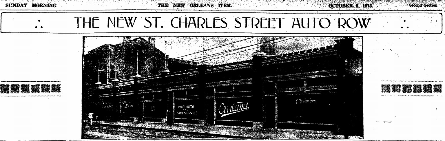
A St. Charles Street "Automobile Row" began to emerge in 1913. Various developers acquired historic residences along the artery between Girod and Julia Streets, and either adapted them or razed them for other use. Julius Koch was awarded a contract to demolish a boarding house and construct a 131' foot showroom (preliminary rendering above; photograph below). Three years later, Koch also designed a new building for the Firestone Tire and Rubber Company.(2)
Not all of the structures listed below are still standing, but most of them are. Some of them feature ornamental automobile symbolism such as wheels and wings.

If you are interested in learning more about the OST Centennial and/or wish to become involved in the planning process, click here.

St. Charles Avenue

1400

M.G. Bernin Motor Trucks (1919)

1423

Motor Car Service Company, Inc. (1920)

1701-11

Abbott Motor Company {Two buildings -- Packard Showroom & Apartments/Showrooms} (1920)

1820 

Packard New Orleans Company (1929)


2001 

Abbott Automobile Company (1920)


St. Charles Street


700

Fairchild Motor Car Company (1917)

706

Woodring-Hamilton Car Company (1916)

714

Ellis Motor Company [formerly King Motor Company] (1920)

721

United Motor Car Company (1920)

726

Safety Tire Repair Company (1916)

728

Hotel Orleans (altered for this use in 1917-1918)

734

Demack Motor Car Company (1918)

735

Herbert E. Woodward Tires (1915)

741

Capital City Auto Company (1915)

742

Moon Agency (1914)

749

L.A.M. Motor Company (1918)

750

B.F. Goodrich Company New Orleans Branch (1914)

752

Abbott Auto Company "Used Car" Department (1919)

759

Stoutz Motor Car Company (1917)

760-762

Willys-Overland Company (1914)

Firestone Tire and Rubber Company (1916)

Freeport & Mexican Fuel Oil Company (1917)

829 

Capital City Auto Company (1919)


And others that were very near to the OST:

Baronne Street

601-603

Charles E. Miller New Orleans Branch [Automobile Sales] (1910)

615-621

Shuler Auto Supply Company Inc. (1919)

618 

M. Zilberman Show Room (1918)

702-716

Abbott Cycle Company (1906)
{They also sold automobile gloves}

Abbott Automobile Company (1908)

751-761

New Orleans Chevrolet Company (1926)

801

Brown Tube Company (1914)

Model Motor Truck Company, Inc. (1917)

821-823 

Abbott Automobile Company, Ltd. (By 1916)

840-842 

Fairchild Auto Company (1910)

Howard Avenue

822

Bernstein Glenny Motor Car Company (1917)

828-832

Lyons-Barton Motor Car Company (1915)
{Constructed using Kahn System}

Julia Street

611

B.P. Braud, Inc. Cord Tire Repairing (1920)


(1)An earlier route kept autoists on the east side of the Mississippi along the River Road.

(2)"Big Auto Tire Company to Make Crescent City Its Distributing Point." The Sunday States 21 May 1916.

Images above: Old Spanish Trail Association. Old Spanish Trail Road Map Southern Louisiana. October 1924. Louisiana Research Collection, Special Collections Division, Tulane University Libraries. Digitally enhanced.

"New Orleans to Have 'Automobile Row' by September 15." The New Orleans Item 12 June 1913.

"The New St. Charles Auto Row." The New Orleans Item 5 October 1913.

Abbott Automobile Company, 2001 St. Charles Avenue. As it appears in The New Orleans Item 12 December 1920.

Fairchild Motor Company, 700 St. Charles Street. As it appears in The New Orleans Item 8 July 1917.

Tuesday, November 24, 2015

Old Marrero Cemeteries

Continuing on yesterday's theme regarding placing and dating historic cemeteries in southeastern Louisiana. . .

Civil engineer (c.e.) James Webb platted the so-called Robinson Avenue Subdivision in early 1921. He based his map on two existing plans, one that c.e. H.L. Zander developed in 1915 (reproduced above as "Exhibit A"); and one that J.W.T. Stephens created in 1919. For surveyors, crediting earlier surveys is an important part of the process: the quality of a new plat depends on the accuracy of its sources.

Zander had attempted to establish the Arpent Tract between the Southern Pacific Railroad and the new Amesville Highway.(1) Identifying the cross-axial artery as "Robinson Lane," Zander referenced the former land holdings of the Robinsons and the Dennises. He also measured two historic cemeteries, one he referred to generically and the other he identified as the St. Joseph Cemetery.

Both cemeteries appear on the Sanborn Fire Insurance Atlas of 1937, which I manipulated below. "A" is the St. Joseph Cemetery and "B" is the unnamed one.

St. Joseph Cemetery is still extant (333 Robinson Avenue) and has been expanded towards its originating worship space. Its historic neighbor is now a near-empty lot.


(1)This later became part of the Jefferson Highway, and today is referred to as Fourth Street.

Images above: Digitally enhanced detail of James Webb, c.e.. Robinson Avenue Subdivision. New Orleans: 5 May 1921. Blue line copy, from Guy Seghers Office Records, Southeastern Architectural Archive, Special Collections Division, Tulane University Libraries. Box 119. Folder 30.

Digitally altered detail of Sanborn Fire Insurance Atlas. Volume 7 [true 11]. Sheet 1119. New York: 1937. As viewed via Digital Sanborn Maps Database, available at Tulane University Libraries.

Monday, November 23, 2015

Old Harvey Cemeteries

Subdivision surveys can help researchers locate historic cemetery sites. The Southeastern Architectural Archive's Guy Seghers Office Records has a considerable number of twentieth-century surveys that document graveyard locations.

The cemetery highlighted above -- in a 1922 Eustis & Bres survey -- was located towards the rear of the Louisiana Cypress Lumber Company's tract along the Harvey Canal in Jefferson Parish. This area was formerly known as the Destrehan Tract, and Joseph Rathborne began to operate a cypress lumber concern here as early as 1889.(1)

By 1940, the Rathborne Land Company was subdividing its massive holdings along the Intracoastal Waterway. The area where the old cemetery had been was redeveloped as a residential section of four- and five-room frame residences. Surveyor Guy Seghers platted the subdivision, noting an existing cemetery along what had been Julia F. Grefer's land (shown below).

This second graveyard is still intact, known as the Evening Star Cemetery [AKA Harvey's cemetery; Harvey cemetery]. Since Hurricane Katrina, it has expanded across Grefer Avenue, absorbing what had formerly been a series of 30' wide residential lots.

Knowing variant geographical names can facilitate the research process. Consulting  GNIS is one means of determining place name changes. For Louisiana, knowing the names of subsequent plantation owners is also beneficial. Marie Adrien Persac's Norman's Chart of the Lower Mississippi River (1858) is one means of determining familial connections, and the United States Mississippi River Commission's Preliminary Map of the Lower Mississippi River: From the Mouth of the Ohio River to the Head of the Passes (1885) is another.

(1)Advertisement. The Times-Picayune 5 July 1948.

Images above: Digitally enhanced detail of Eustis & Bres. LA Cypress Lumber Co. Tract. Survey. 1922. Box 120. Folder 45.

Digitally enhanced detail of Guy J. Seghers. Industrial Subdivision of Property of Joseph Rathborne Land Company, Inc. Harvey, Louisiana. 10 October 1940 with annotated corrections to February 1944. Box 120. Folder 29.

Both Guy Seghers Office Records, Southeastern Architectural Archive, Special Collections Division, Tulane University Libraries.


Friday, November 20, 2015

Ithiel Town & New Orleans

The Southeastern Architectural Archive retains an important letter written by New York architect-engineer Ithiel Town (1784-1844) regarding his improved Lattice Bridge design of 1835. When the document came on the market, William Cullison III acquired it with support from the Marjorie Peirce and John Geiser, Jr. Fund.

Dated 23 July 1836, it gives illustrated instructions for a proposed bridge spanning 250 feet, with trussing extending 300 feet. Town advises the recipient, Boston carpenter John Livermore, to use either spruce or pine planks configured in a repeating diamond pattern, and sets a “lowest” price of $1/foot for “the whole length of the trusses of the bridge.” 

Town was a prominent New York architect and engineer known for his patented bridge. He promoted the innovation in various classified advertisements, professional publications and correspondence, thus securing its use from New York to Alabama.

New Orleans architects James Dakin, James Gallier, Sr., and Robert Seaton worked for Town before moving South; Minard Lafever also knew him. In January 1835, Town expressed an interest in visiting Louisiana to establish new bridge contracts.(1) 

(1)Ithiel Town (New York). Letter to Seth Shine (Tuscaloosa, Alabama). 17 January 1835. Cited by Jim Wilson, "Letter approving the contract to build a bridge across the river at Wetumpka." As viewed 20 November 2015. URL: http://files.usgwarchives.net/al/elmore/letters/w-bridge.txt

Image above:  Ithiel Town. Lattice Bridge Diagram. Pen and ink on paper. 1836. Marjorie and John Geiser II Collection, Southeastern Architectural Archive, Special Collections Division, Tulane University Libraries.

Thursday, September 24, 2015

Shreve's Cut-Off

An earlier post announced the Southeastern Architectural Archive's processing of Benjamin Morgan Harrod's Mississippi River Atlases.

The earliest volume, The Preliminary Map of the Lower Mississippi River (1881-1885), was printed by Julius Bien after maps by Edward Molitor, but someone -- possibly Harrod -- added penciled annotations to certain plates. Sheet No. 22, dated 1884, includes a number of these sketched amendments.  They center on Shreve's Cut Off between Carr's Plantation landing and S.L. James's Angola Plantation  landing (detail above).


Here is a more expansive view of the stretch today, from Google Maps.


Wednesday, September 23, 2015

Underneath

We frequently respond to inquiries regarding foundations -- researchers want to know what is underneath a given building or monument.

During the 1930s, there was considerable interest in collecting and compiling information related to the geology of New Orleans. Local engineers had long advocated the need for a comprehensive assessment, but it was not until President Franklin Delano Roosevelt created the Works Progress Administration (WPA) that Louisiana had the requisite funds.  The State Board of Engineers endorsed and sponsored WPA projects to document soil and foundations, and to develop accurate elevation datum.

The WPA created the Louisiana Geodetic Survey’s Precise Elevations: City of New Orleans (1937) to record modern datum planes. Prior assessments had been generated by various federal, state and municipal government entities for their own purposes. These data sets proved divergent and did not reflect ground surface settlement changes resulting from early twentieth-century drainage modifications. Precise Elevations set the new WPA datum planes (measured in 1935), compared against the historic data compiled by the Dock Board, the Levee Board, the Sewerage and Water Board, and the United States (Army) Engineering Department.

The WPA’s survey Some Data in Regard to Foundations (1937) was a comprehensive assessment of the variable soil conditions underlying New Orleans, and their effects on historic and contemporary construction. WPA researchers spent two years consulting public and private records, and soliciting anecdotal and illustrative documentation from architects, engineers and builders. They gathered cartographic records, foundation plans, stratigraphic and piling data to chronicle historic construction methods aimed at tackling the city’s alluvial soils. In the process, they measured and rendered the city’s notable structures, including the American Bank Building, the Lakefront (formerly Shushan) Airport, and the U.S. Marine Hospital complex.

The WPA also documented such works as the Robert E. Lee Monument located in Lee Circle at the intersection of St. Charles Street and Howard Avenue.  Alexander Doyle (1857-1922) and Confederate veteran John Roy designed the monument, which was unveiled 22 February 1884.  The WPA estimated that the monument weighed a total of 1,141 tons which was dispersed to its 81 untreated, unpeeled red cypress piles (detail above). Excavation work conducted in 1929 revealed that over half of the piles' lengths (varying from 40-49' feet) were situated below the water line.

Images above:  "Case No. 56. Lee Monument." Some data in regard to foundations in New Orleans and vicinity. Collected and compiled by the Soil and foundation survey as requested by Louisiana engineering society. A project of the Works Progress Administration of Louisiana. New Orleans: 1937, pp. 170-171. Available at Tulane University Libraries.

Wednesday, April 1, 2015

Street Addresses

We are developing a series of blog posts pertaining to Frequently Asked Questions. In the last post, we addressed finding information about historic New Orleans mill work.

With today's post, we want to focus on ways in which to establish variant street addresses associated with a given property. Tracking down information related to corner lots can be especially tricky because business owners and tenants (especially saloons) would often alter address information with some frequency.  When we came across the stretch of St. Bernard Avenue shown above -- which boasts three completely different street numbers above its roll down security shutter, it provided us with the opportunity to mention some helpful resources.

If you don't know the name of the owner, tenant or business associated with a property,* fire insurance atlases can be especially beneficial tools for establishing historic street addresses. Most researchers are familiar with those produced by the Sanborn Map & Publishing Company. It is worth mentioning that for New Orleans, there were a number of notable late nineteenth century atlases independently developed by surveyor-architects Braun, Celles and Langermann.

Establishing the municipal district and square number for a property can be a great starting place. An easy way to do this is to consult the City of New Orleans Property Viewer and the District Guide to the Robinson Atlas. Using that method for the property shown above yields the following information:

Municipal District 3
Square 378 B 

John Braun's 1877 atlas shows the irregularly shaped square as:
As you can see, St. Bernard did not run through Rampart and St. Claude during that period. Square 378 had not yet been divided into two parts, A and B. Braun utilized the old street numbering system, which was replaced in 1895.

Nearly twenty years later, the Sanborn Company similarly mapped the square, this time with the new street numbering system in place:
When the company documented it again in 1908, it remained much the same. But between 1908 and 1934, the square changed dramatically:
The riverside section of North Rampart Street was widened and renamed McShane Place, and St. Bernard was cut between St. Claude and McShane. Square 378 was now divided in half and significantly reduced in scale.

By 1964, what had been a residential square had largely become commercialized. Structures in close proximity to the corner filling station were built of concrete block ("C.B." in blue).


Knowing the variant street addresses for a property provides researchers with additional access points by which they may search historic newspapers, legal documents and surveyors' records. The Southeastern Architectural Archive's Guy Seghers Office Records, for example, is largely organized by municipal district and square number. Searching historic newspaper databases using variant street addresses can be especially beneficial.

For online access to Sanborn Fire Insurance Atlases, consult Tulane University Libraries' Databases.

Images above:  1131-1139 St. Bernard Avenue. Google Street View. April 2014.

"Square 378." John Braun. Plan book of the third district comprising 7th., 8th., and 9th., ward, New Orleans; showing subdivisions of squares, with the present improvements thereon. New Orleans, 1877. Southeastern Architectural Archive, Special Collections Division, Tulane University Libraries.

"Square 378." Sanborn Atlas, 1896. Southeastern Architectural Archive, Special Collections Division, Tulane University Libraries.

"Square 378" Sanborn Atlas, 1908 corrected to 1934. Southeastern Architectural Archive, Special Collections Division, Tulane University Libraries.

"Square 378." Sanborn Atlas, 1937 corrected to 1964. Southeastern Architectural Archive, Special Collections Division, Tulane University Libraries.

*If you do know this information, city directories can yield street address information. Most of New Orleans' city directories are digitized and available through Tulane University Library's subscription to Ancestry Library.


Thursday, March 5, 2015

KUDOS to the Digital Commonwealth. . .

For digitizing the Norman B. Leventhal Center map collection. The Center, part of the Boston Public Library system, is dedicated to the creative educational use of its cartographic holdings. They have created a fantastic GIS-based interface.

The map reproduced above is an inset map titled Plan de la ville de la Nouvelle Orleans telle quélle était en mai 1728, and it includes the names of property owners for  Vieux CarrĂ© structures originally documented by the French cartographer Jean-Baptiste Gonichon.

Image above: Francis Barber Ogden, cartographer; Peter Maverick, engraver. Inset map from To General Andrew Jackson and his brave companions in arms on the 8th of Jany. 1815 this plan of the city of New Orleans is respectfully dedicated. 1829.Map reproduction courtesy of the Norman B. Leventhal Map Center at the Boston Public Library.

Tuesday, February 10, 2015

1883 Robinson Atlas

The Southeastern Architectural Archive (SEAA) and the Tulane University Libraries' Preservation Department recently completed an exciting conservation project. An important New Orleans fire insurance atlas has been cleaned, mended and housed in a custom-made protective enclosure. It is now accessible to researchers for the first time in decades. Known most commonly as the Robinson Atlas, the work was published under the title Atlas of the City of New Orleans, Louisiana, based upon surveys furnished by John F. Braun, surveyor and architect, New Orleans.

Based on district maps that architect-surveyor John Braun developed in the 1870s, the Robinson Atlas represents the finest in accurate insurance mapping. It was printed in Philadelphia by A.H. Mueller and F. Bourquin and published by New Yorkers Robinson & Pidgeon. The latter produced a number of municipal fire insurance atlases in the early 1880s, the most notable of which are the ones for Chicago, New Orleans and New York.

Individual sheets are lithographed. Text blocks were engraved by A.H. Mueller.

Although the New Orleans Notarial Archive digitized its Robinson Atlas many years ago, it did not include the index maps that provide critical content, including the map key. The SEAA's holdings include two index maps, and both variants have been conserved.

Image above:  Index map. Detail. Atlas of the City of New Orleans, Louisiana, based upon surveys furnished by John F. Braun, surveyor and architect, New Orleans. Published by E. Robinson, New York. [AKA The Robinson Atlas]. 1883.


Wednesday, January 14, 2015

Battle of New Orleans Site

Since the National Park Service is celebrating the Bicentennial of the Battle of New Orleans this holiday season, we decided to feature some early surveys of the site. These are photostat copies of the original surveys that were collected by Guy Seghers, whose office records are retained by the Southeastern Architectural Archive and the Historic New Orleans Collection. 

BarthĂ©lemy Lafon (1769-1820) developed the survey shown above while employed as deputy surveyor under Isaac Briggs (1763-1825). Thomas Jefferson had appointed Briggs "Surveyor of the Lands of the United States, South of the State of Tennessee" in 1803 and one year later Briggs was assigned to develop a post road from Washington to New Orleans. Lafon's survey records the plantation properties of J.M. Pritchard, Mssrs. PrevĂ´t and Chalmette. Signed 13 February 1808, "la 32eme annĂ© de l'IndĂ©pendence des Etats-Unis de l'AmĂ©rique," the document primarily records PrevĂ´t's landholdings from the Mississippi River to a grove of trees. A drainage canal separates the plantations of Pritchard and PrevĂ´t.
The second survey -- surviving as a fragment -- was signed in New Orleans on the 20th of March 1878. It records the town of Fazendville, then consisting of twenty lots, each measuring 120 feet in depth and sharing a common alley. By this time the area was unified by a levee road and a larger canal (dating to January 1815) was in place.The city and the United States government claimed nearby parcels.

Images above: Photostat copies of surveys. Folder 4, Box 109. "Battle of New Orleans Site, St. Bernard Parish." Guy Seghers Office Records, Southeastern Architectural Archive, Special Collections Division, Tulane University Libraries.

Friday, November 14, 2014

Edgewood Park

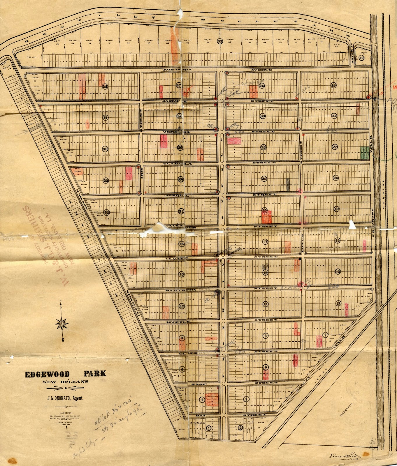
This fall the National Park Service approved New Orleans' Edgewood Park neighborhood's inclusion on the National Register of Historic Places. The subdivision was developed in 1909 on the former Dennis Sheen Tract, originally bounded by the Louisville & Nashville Railroad, the New Orleans and Northeastern Railroad, Gentilly Boulevard and Clematis Avenue. This tract was desirable pasture land covered in blackberry bushes and grass, located along a natural ridge. Real estate developer J.L. Onorato secured an option on the property in February 1909. The following month, the New Orleans Railway Company announced it would extend its Villere streetcar line a mile beyond the Franklin Avenue/Galvez Street stop in order to provide service. Soon thereafter, consulting engineer Warren B. Reed platted the subdivision with all lots measuring 30' x 120'.  Early purchasers had a tendency to buy two adjacent lots (map above). By spring of 1910, Onorato sold a large number of Edgewood's remaining lots to Grover & Leyman, an Indianapolis-based real estate investment firm.

The neighborhood includes a large number of bungalows.

Image above: William Reed, consulting engineer. Edgewood Park, New Orleans. /J.L. Onorato, Agent. May 1909. Guy Seghers Office Records, Southeastern Architectural Archive, Special Collections Division, Tulane University Libraries.

Wednesday, October 8, 2014

Lexicon: Telluric Upheavals

Tales of Telluric Upheavals, Mississippi River

Report on the Lighthouse at Frank's Island & On the Balize, May 8th, 1819, by B.H.B. Latrobe, Esq.

"Frank's Island contains now (May, 1819) 1 acre 2 Rodd 31 P. or about an acre & a half of solid & elevated land. When the commissioners selected it, it was something larger. But the violent gale of Sept'r 8th, 1819, washed away a considerable part of the island, especially on the southeast side, & something also on the north, & has a perpendicular margin, which gives to the surf a much more powerful effect than formerly; & on this account the encroachment of the water upon the shore has been considerable since the gale of September last, without any storm having occurred.

"Very effectual means were therefore immediately necessary to secure the shores from farther waste: nor can there be in my opinion the smallest doubt but that the whole island would be gradually lost unless the measures had been taken, which I have sometime ago the honor to recommend, & that the U. States Government will sanction them, altho' there has not been time to await their decision. In the drawing annexed to the report I have laid down the Island, as it exists together with the line of wharfing which is now in progress. Both with a view to lessen the extent & expense of this work & in order to obtain earth to fill in behind the wharf, I have recommended that the north end of the island be cut off. It is at present the brick yard, but it is daily wasting. A part of the shore fell in while I stood below upon its margin. The southwest end of the island is perfectly secure, being protected by an extensive marsh, across a bayou of no great breadth or depth of water.

"Around the island is a mud shoal, which daily grows shallower."(1)


"The Sinking of the Louisiana Coast." The Daily Picayune 18 April 1894.

"A few days ago the Picayune printed some remarks of Mr. E.L. Corthell, the Civil Engineer, who was associated with Captain Eads in the building of the jetties in South Pass of the Mississippi River, on the sinking of the coast near the mouth of the river.

"Mr. Corthell did no promise to give expression to any opinions as to a general subsidence of the low country of Louisiana, but only of that part to which his attention had been strictly confined. He states that when he was engaged in building the jetties, in the period from 1875 to 1879, an object of great interest was the old Spanish fort, built of brick, on the east side of Garden Island Bay and near the formerly used Southeast Pass, a mouth of Pass-a-Loutre. There seemed to have been a uniform subsidence of this fort, not from settling into the ground -- for there were no indications by cracks or leaning to show that this was the case -- but by evidently going down steadily with the ground on which it rested and which was, no doubt, sinking steadily. The mean level of the Gulf was up near the top of the door, which fact is pretty good evidence that general subsidence caused it.

"As to bench marks at the mouth of the river, there are several there, and also, no doubt, sea-level marks on old trees or buildings; but, until recently, no precise levels were over run from solid ground. The Mississippi River Commission has recently extended its levels to Port Eads and checked on the benches and on the Gulf level there. The results of those levels are of interest and no doubt they will be available in due time.

"Ten or twenty years from now, should these levels be run from the high country again to Port Eads, the progressive subsidence of the delta will be ascertained with some degree of accuracy.

"The fact of this subsidence of the coast is very interesting, and it is entirely possible that it is not confined to the region immediately near the mouths of the Mississippi River. It may cover an area much more extensive, and, if so, it will be of much scientific importance to determine its rate and range. The forces that work great telluric changes commonly operate with extreme slowness; but there have been within the historic period movements of upheaval and of subsidence of the earth's surface that were not only of great violence, but also of great extent.  The entire subject is one of much interest to a large body of people."


(1)As reproduced in Benjamin Henry Boneval Latrobe. Impressions Respecting New Orleans: Diary and Sketches, 1818-1820.  Edited and with an introduction by Samuel Wilson, Jr. New York: Columbia University Press, 1951.

26.2.1 General records. Correspondence of the Secretary of the Treasury, Commissioner of Revenue, and Fifth Auditor of the Treasury, relating to lighthouses, 1785-1852. Records of the United States Coast Guard. National Archives, Washington, D.C.

Friday, March 7, 2014

Bungalow Subdivisions 1909-1945

We are in the process of developing a new exhibit that focuses on bungalow and cottage architecture in the Gulf South. If you are interested in learning more about the development of bungalow subdivisions in metropolitan New Orleans, check out our guide here.

Not all attempts to develop bungalow subdivisions were successful, especially those that were detrimentally impacted by the Great Depression. One "bust" subdivision -- Riverside Park -- was originally platted by surveyor Elbert G. Sandoz for developers Murphy & Levy in 1923. Contractors Villere & Bertucci completed some of the requisite infrastructure (culverts, cypress removal) in 1924, but by the time Farm Security Administration photographer Russell Lee (1903-1986) visited Harahan in 1938, very little survived. Today, there are remnants of the Park Avenue neutral ground entrance.
New Orleans architect Francois P. Dufrechou, Jr. (1894-1952) designed the subdivision's fountain entrance, shown above.


For more on the history of Riverside Park, consult the Southeastern Architectural Archive's Guy Seghers Office Records.

Top above: Everett S. Dodds, architect. Kelso Model Home. From Build A Dodds Home: Beauty, Comfort and Durability.  Red Oak, Nebraska: The Thomas D. Murphy Company,  1920s. Architectural Trade Catalogs, Southeastern Architectural Archive, Special Collections Division, Tulane University Libraries.

Lower images:  Russell Lee, photographer. Riverside Park, "Bust" Real Estate Development North of New Orleans, Louisiana. September 1938. As viewed via the Library of Congress Prints & Photographs Division Online Catalog.

Monday, January 6, 2014

Cartographic Records

For those who are interested in learning more about the cartographic holdings of the Southeastern Architectural Archive, you may want to consult this recent article in Cartographic Perspectives.

Image above: Louis Bringier, surveyor. Plan of the Gurlie Property Divided into Lots Situated between Bayou Road and Canal Carondelet.  30 July 1836. [Detail]  Second District (Oversized). Guy Seghers Office Records, Southeastern Architectural Archive, Special Collections Division, Tulane University Libraries.

Wednesday, December 4, 2013

Goodwill Industries

For those wondering about the building located at 2000 Jackson Avenue that is being demolished today (google streetview above), the structure underneath was designed by New Orleans architect Edward B. Silverstein for Goodwill Industries in 1958. His commission required the inclusion of a chapel, loading platform, terrace, kitchen, offices, a large work area and a salesroom for the nonprofit organization's job-training operations. Only the former sales and work areas lasted until 2013, and the exterior had been dramatically altered.

When Silverstein started the project in 1957, he hired surveyor F.C. Gandolfo, Jr. to review earlier surveys and develop new measurements for the existing conditions at the site.

Lot 24A was the Old Hebrew Rest Cemetery, partially bordered by a brick fence and remnants of its foundations, and dotted with "miscellaneous rubble and old tombs" and an established mulberry tree, hackberries, cedars and oleanders. Goodwill Industries acquired the site from Touro Synagogue -- which had owned the property since 1828 -- in August, 1957. The cemetery had not been used as a burial site for decades, and the New Orleans Rabbinical Council made arrangements for appropriate reinterments.

After the site was cleared, pile driving commenced on 30 October 1958. Mayor deLesseps Morrison cut the ribbon at the building's formal dedication on 24 September 1959.

Second Image:  Edward B. Silverstein, Architect. Goodwill Industries. Detail of East Elevation. 17 February 1958. Edward B. Silverstein Office Records, Southeastern Architectural Archive, Special Collections Division, Tulane University Libraries.

Third Image: F.C. Gandolfo, Jr., surveyor for Mr. Ed. Silverstein, Arch. Lot 24A Square 299 Fourth District. 20 May 1957. Edward B. Silverstein Office Records, Southeastern Architectural Archive, Special Collections Division, Tulane University Libraries.

Wednesday, November 27, 2013

Mapping the Gulf South

For those traveling over the holidays, you may want to visit the new Tampa Bay History Center. In September the interactive museum launched a major map exhibition, featuring over 150 atlases, maps, globes and other cartographic material dating from 1493 to 2013. It includes the Ptolemaic world map from the Nuremberg Chronicle, "La Florida" from Ortelius'  Theatrum Orbis Terrarum (detail above), a seventeenth-century Florentine chart of the Gulf of Mexico, Pierre Mortier's The Theater of War in America and more recent bird's eye view perspectives of the region. Current digital images taken by NASA and the Google mapping project round off the exhibit.

For more information about "Charting the Land of Flowers: 500 Years of Florida Maps," consult the museum's online guides. And congrats to map collector/historian Tom Touchton!

UPDATE:  The exhibit has now been extended through April 13 2014.

Image above: GerĂ³nimo de Chaves (1524– ?). La Florida from the Theatrum Orbis Terrarum of Abraham Ortelius, Additamentum of 1584 (1591 or 1592 Latin edition). Detail. Tampa Bay History Center.

Friday, November 22, 2013

NEW! James Freret Finding Aid

The Southeastern Architectural Archive recently finalized the processing of the James Freret Office Records. The collection consists of Grand Tour travel sketches, architectural project and spec drawings, and financial records associated with New Orleans architect James Freret (1838-1897). Read more about the architect and the collection here.

Image above: Joseph PiliĂ©, voyer de la ville, Nouvelle OrlĂ©ans le 8 Avril 1826. Plan de division en trois lots, d’une portion de terre sur laquelle il Ă©xiste des maisons, situĂ©e au Faubourg Ste Marie, Ă  l’encoignure des rues Poydras et Carondelet et appurtenant Ă  Mr Valentin Daublin. Folder 8, James Freret Office Records, Southeastern Architectural Archive, Special Collections Division, Tulane University Libraries.

Friday, September 20, 2013

Lost Carrollton


New Orleans architect C. Milo Williams (1867-1954) took an interest in the old Porter residence, located at the intersection of Levee and Monroe Streets in Carrollton. According to Williams, the structure was constructed of Hoey's bricks, and was one of the oldest buildings standing in Carrollton. He photographed the building prior to its demolition in the early twentieth century (top image).

His father, William H. Williams (1817-1886) had also taken an interest in the Porter properties and the Hoey brick operations.  In 1878, he copied an 1845 D'Hemecourt survey of the Porter properties and sketched the building's basic plan (second & third  images). The elder Williams also developed a proposed levee plan for John Hoey's brick operations in November 1865 (bottom image), the year prior to the plantation owner's death.

All of these historic sites no longer exist, although the Hoey residence, constructed for John Hoey's widow Carolyn Pierce Hoey (1871) remains at 7933 Willow Street. Louisiana Research Collections (LaRC) retains John Hoey's papers, including his brickyard account ledgers.

Images:

Top: C. Milo Williams, photographer. Porter residence, 8643 Levee Street/806 Monroe Street. Before 1909. Williams Family Records, Southeastern Architectural Archive, Special Collections Division, Tulane University Libraries.

Second & Third: William H. Williams, surveyor. Surveys of Porter Property. Notebook No. 86. From 3 January 1878. William H. and C. Milo Williams notebooks, Louisiana Research Collection, Special Collections Division, Tulane University Libraries.

Bottom: William H. Williams, surveyor. Diagram of Hoey's Levees. Notebook No. 43. November 1865. William H. and C. Milo Williams notebooks, Louisiana Research Collection, Special Collections Division, Tulane University Libraries.

Thursday, September 19, 2013

The Fatal Switch


In the summer of 1891, New Orleans architect-engineer C. Milo Williams (1867-1954) traveled to Sauvé (Jefferson Parish), five miles outside of New Orleans. He witnessed the wreckage of a head-on train collision that had occurred on the Illinois Central Railroad line near Sauvé station (top image above). The I.C.R.R.'s "Cannon Ball" mail and passenger train smashed into a Toledo, St. Louis and Kansas City freight train, resulting in four fatalities and many other serious injuries. Both engineers died immediately. Newspapers referenced the "fatal switch," alleged conductor and brakeman fault, and charged that no warning lights were in use.(1)

C. Milo Williams later photographed safety improvements along the same I.C.R.R. track (lower image). He indexed his series of  images "Bofinger switches" in reference to New Orleans businessman-inventor William H. Bofinger. Just a few days before the SauvĂ© collision, Bofinger had received a patent for a new switch that allowed an engineer on a moving train to "throw the point of the switch against the main track without leaving his engine."(2)  A few months after the accident, Bofinger filed a second railroad patent, his so-called "switch-stand'" -- essentially a cage-enclosed switch that prohibited tampering. It is the latter that Williams documented in Jefferson Parish.

Among Bofinger's less safety-conscious inventions, one must mention his 1894-95 Rocking Chair Fan Attachment.

(1)"The Crash of the Cannon Ball." The Daily Picayune (21 June 1891): p. 4.

(2)No. 453,690. Patented June 9,1891.

Images above: C. Milo Williams, photographer. Williams Family Records, Southeastern Architectural Archive, Special Collections Division, Tulane University Libraries.