William H. Sadlier Company published the first two volumes of its Excelsior Geography in 1875. An additional volume appeared the following year. The works were part of a series that the Sadlier family developed to serve parochial school educators who lamented the anti-Catholic sentiment they discerned in American textbooks.
Sadlier's secondary school publications became quite popular, and garnered attention at the 1878 Paris Exhibition. Many went through multiple editions, as did its three-volume geography primer.
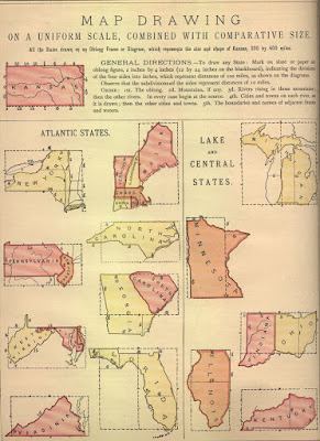
The plate reproduced above, "Map Drawing on a Uniform Scale, Combined with Comparative Size," provides general instructions based on a uniform scale. The anonymous author set Kansas as the basis for mapping out the other states, the rectangular module for the United States. Its proportional relationship of 1:2 (200 miles x 400 miles) made it particularly easy to scale. For those states with more irregular borders, the author recommended employing comparative size.
See more geography instruction manuals here.
Image above: "Map Drawing on a Uniform Scale, Combined with Comparative Size." As it appears in Anonymous ["A Catholic Teacher"]. Sadlier's Excelsior Geography, 2nd ed. New York: William H. Sadlier, 1887. Ben A. & Sylvia S. Smith American Geography and Social Studies Education Collection, Richard L. D. and Marjorie J. Morse Department of Special Collections, Kansas State University Libraries.
Friday, April 8, 2016
Subscribe to:
Post Comments (Atom)

No comments:
Post a Comment