Showing posts with label highways. Show all posts

Tuesday, December 15, 2015

OST Hot Spots

Since I attended the Old Spanish Trail Centennial Celebration in Mobile, Alabama last week, I've been thinking about how the Good Roads Movement affected commercial architecture. Tracking down relevant structures requires mapping OST road beds and cross-checking Sanborn data sets, building plans and historic newspaper accounts.

The route -- highlighted above -- took westbound travelers through the Crescent City along Bayou Sauvage/Gentilly Road to North Broad  (via Paris) on to Canal, St. Charles, Broadway and ultimately to the Westwego-Walnut Street ferry.(1)

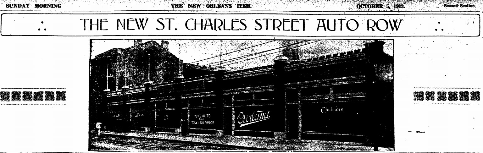
A St. Charles Street "Automobile Row" began to emerge in 1913. Various developers acquired historic residences along the artery between Girod and Julia Streets, and either adapted them or razed them for other use. Julius Koch was awarded a contract to demolish a boarding house and construct a 131' foot showroom (preliminary rendering above; photograph below). Three years later, Koch also designed a new building for the Firestone Tire and Rubber Company.(2)
Not all of the structures listed below are still standing, but most of them are. Some of them feature ornamental automobile symbolism such as wheels and wings.

If you are interested in learning more about the OST Centennial and/or wish to become involved in the planning process, click here.

St. Charles Avenue

1400

M.G. Bernin Motor Trucks (1919)

1423

Motor Car Service Company, Inc. (1920)

1701-11

Abbott Motor Company {Two buildings -- Packard Showroom & Apartments/Showrooms} (1920)

1820 

Packard New Orleans Company (1929)


2001 

Abbott Automobile Company (1920)


St. Charles Street


700

Fairchild Motor Car Company (1917)

706

Woodring-Hamilton Car Company (1916)

714

Ellis Motor Company [formerly King Motor Company] (1920)

721

United Motor Car Company (1920)

726

Safety Tire Repair Company (1916)

728

Hotel Orleans (altered for this use in 1917-1918)

734

Demack Motor Car Company (1918)

735

Herbert E. Woodward Tires (1915)

741

Capital City Auto Company (1915)

742

Moon Agency (1914)

749

L.A.M. Motor Company (1918)

750

B.F. Goodrich Company New Orleans Branch (1914)

752

Abbott Auto Company "Used Car" Department (1919)

759

Stoutz Motor Car Company (1917)

760-762

Willys-Overland Company (1914)

Firestone Tire and Rubber Company (1916)

Freeport & Mexican Fuel Oil Company (1917)

829 

Capital City Auto Company (1919)


And others that were very near to the OST:

Baronne Street

601-603

Charles E. Miller New Orleans Branch [Automobile Sales] (1910)

615-621

Shuler Auto Supply Company Inc. (1919)

618 

M. Zilberman Show Room (1918)

702-716

Abbott Cycle Company (1906)
{They also sold automobile gloves}

Abbott Automobile Company (1908)

751-761

New Orleans Chevrolet Company (1926)

801

Brown Tube Company (1914)

Model Motor Truck Company, Inc. (1917)

821-823 

Abbott Automobile Company, Ltd. (By 1916)

840-842 

Fairchild Auto Company (1910)

Howard Avenue

822

Bernstein Glenny Motor Car Company (1917)

828-832

Lyons-Barton Motor Car Company (1915)
{Constructed using Kahn System}

Julia Street

611

B.P. Braud, Inc. Cord Tire Repairing (1920)


(1)An earlier route kept autoists on the east side of the Mississippi along the River Road.

(2)"Big Auto Tire Company to Make Crescent City Its Distributing Point." The Sunday States 21 May 1916.

Images above: Old Spanish Trail Association. Old Spanish Trail Road Map Southern Louisiana. October 1924. Louisiana Research Collection, Special Collections Division, Tulane University Libraries. Digitally enhanced.

"New Orleans to Have 'Automobile Row' by September 15." The New Orleans Item 12 June 1913.

"The New St. Charles Auto Row." The New Orleans Item 5 October 1913.

Abbott Automobile Company, 2001 St. Charles Avenue. As it appears in The New Orleans Item 12 December 1920.

Fairchild Motor Company, 700 St. Charles Street. As it appears in The New Orleans Item 8 July 1917.

Monday, November 30, 2015

NEW! Rock & Galloway Finding Aid

The Southeastern Architectural Archive has finalized the processing of the Rock & Galloway Office Records.

The collection includes correspondence, drawings, photographs, presentation boards, models and specifications. Researchers should note that most residential plans were given to individual clients, and the collection subsequently does not provide full insights into the firm's private commissions.

Read more about the collection via the SEAA's Finding Aids by Name.

Monday, June 22, 2015

Louisiana Penal Labor (1930)

In 1930, Transmissions, a New Orleans journal devoted to "the interests of motor transportation" honed in on the use of prison laborers to make highway signage. With the photograph shown above, its editors championed Governor Huey Long's efforts to expand the state's infrastructure without increasing taxes. They captioned the image "Convicts Making Road Signs Reduces Costs." A small guard station and two fencing perimeters can be seen in the distance of the signage yard.

Image above: "Convicts Making Road Signs Reduces Costs." Transmission: A Journal Devoted to the Interests of Motor Transportation and Police Jury Affairs 3:2-3 (February-March 1930). Courtesy Louisiana Research Collection, Special Collections Division, Tulane University Libraries. Current call number is 976.3 (388.105) L891

Friday, April 17, 2015

BLOG 225K

As of today, the Southeastern Architectural Archive's "Architecture Research" Blog has tallied 1/4 million page views.  What was initiated as an attempt to provide a research portal has resulted in both a tool and a reference publication.

Happy Milestone!

Image above: Truscon Steel Company. "Welded Steel Fabric for Permanence, Contraction Joints for Safety/Bars for Reinforcing, Road Forms for Speed." From Modern Road Construction. Youngstown, OH: The Company, 1930. Architectural Trade Catalogs, Southeastern Architectural Archive, Special Collections Division, Tulane University Libraries.

Wednesday, October 1, 2014

Detroit Public Library - NEW Digital Resource

Last night, the Detroit Public Library [DPL] completed a mass digitization project pertaining to its Special Collections holdings, including over 33,000 images from its National Automotive History Collection [NAHC].  For those of us in the Gulf South, this is an incredible resource because it includes digital reproductions of early twentieth-century levees, roadways, cities, towns, automobile parades and "tin-can" camps. The digital collection is especially strong for Florida, where early automobile enthusiasts ventured in great numbers.

The image clipped above relates to Captain Walter Wanderwell and a drive he took through a flooded road in Mississippi.  According to historian Dan Treace -- who is currently building a replica of Wanderwell's Unit 2 -- in 1919 the former POW purchased a used Ford chassis in Detroit, Michigan and had it shipped to New Orleans, where it was modified. The Times-Picayune reported that it was retrofitted with a water tank and fifty-four-gallon gasoline tank. Wanderwell headed out from Atlanta on September 22, 1919 in order to retrieve his new car.

Asked to comment on Louisiana's roads when he arrived in New Orleans in March 1920, Wanderwell remarked, "'Louisiana has some of the best roads and some of the worst. When we were a little way out of Bogalusa it took us six days to make sixty-five miles, which we make in an hour on a good road.'"(1)

From New Orleans, Wanderwell, his wife, mechanic, photographer and correspondent headed West on the Old Spanish Trail.

Read more here.

Access the collection here.

(1)"Peiczyniki [sic], Touring World, Is In Orleans." The Times-Picayune 15 March 1920.

Friday, September 26, 2014

NOLA at the Crossroads

In 1924, Highways 1, 2, 12 and 54 were starting to converge on New Orleans. The Mississippi River Scenic Highway, Jefferson Highway, the Old Spanish Trail  and the Jefferson Davis Highway represented the significant efforts of automobile boosters, government leaders and civic organizations to bring good roads into the Crescent City. Frequent rainfall and flooding often impeded visitors' abilities to enter the city by automobile.

In the early 1920s, photographer Mary Crehore Bedell and her physicist-husband Frederick took an arduous 12,000-mile road camping trip to encircle the United States. She documented the adventure in her book, Modern Gypsies (Brentano's, 1924).  Hoping to visit friends in New Orleans, the Bedells learned that the road from coastal Mississippi to New Orleans was mired in mud, as were roads along the Mississippi River to  the North. They opted to store their Hupmobile and took a train into New Orleans.


Images above:  Top:  Details. Rand McNally Junior Auto Trails Map: Louisiana. F-23 from Rand McNally Commercial Atlas of America (1924).

Bottom:  J.P. Troy, photographer. Mary Crehore and Frederick Bedell in Their Hupmobile. From Mary Crehore Bedell. Modern Gypsies. New York: Brentano's, 1924.

Thursday, April 3, 2014

1958 Airline Highway

In 1958, New Orleans photographer Frank Lotz Miller (1923-1993) shot this series of Airline Highway photographs for architects Curtis and Davis, who renovated the London Lodge Motel and Restaurant. The complex's predecessor structures -- a tourist court assemblage -- had been designed by Patrick M. Allison for Chicago owner Ben London in 1952.

Images above:  Frank Lotz Miller, photographer. Airline Highway/London Lodge Motel. 1958. Digital image from black and white negative. Curtis and Davis Office Records, Southeastern Architectural Archive, Special Collections Division, Tulane University Libraries.

Monday, December 6, 2010

North Claiborne Avenue 1972


In 1972, Tulane School of Architecture faculty member John Rock (1923-2009) took his camera on the road, recording the sites along North Claiborne Avenue underneath the elevated I-10 and the construction of the newer I-10 sections near the Orleans Parish Prison. Taken from a moving vehicle, some of his slides are quite blurred, yet they provide strong documentation of North Claiborne and the shaded artery provided by the expressway.

Images above: John Rock, photographer. I-10 Expressway, New Orleans. February 1972. John Rock Collection, Southeastern Architectural Archive, Special Collections Division, Tulane University Libraries.

Tuesday, July 21, 2009

Transportation Leviathan

As the New Orleans Master Plan discussions currently involve the removal of the raised I-10 expressway through the Sixth and Seventh Wards, it seemed an appropriate time to resurrect some ephemera related to the initial grass roots effort focused on keeping the highway off the riverfront area.

Image above: Louisiana Council for the Vieux Carré. The Elevated Riverfront Expressway, undated flyer. Louisiana Research Collections, Special Collections Division, Tulane University Libraries.

Monday, October 20, 2008

Highways and Neighborhoods

The transformation of live oak-filled public boulevard space along Claiborne Avenue into the roadway deck for elevated Interstate I-10 dramatically altered Sixth and Seventh Ward New Orleans, much as the routing of Interstate I-35 affected the Rondo neighborhood in St. Paul, Minnesota and Interstate I-275 impacted West Tampa, Florida. All three areas were home to tight-knit, fiercely independent and mixed race communities. Rondo's identity as a neighborhood was nearly erased by the highway construction; today it is largely known through oral histories and individual memories. West Tampa is being altered once again, this time by I-275 expansion for Florida's burgeoning population of motorists. To read a blogger's perspective, click here.

Thirty-eight years ago, the New Orleans Tambourine and Fan Club, a neighborhood-based cultural organization associated with the Sixth and Seventh Wards, initiated a revitalization effort for the Claiborne Avenue Corridor. By November 1973, the Claiborne Avenue Design Team (CADT) was formed and began a three-year multi-disciplinary planning process to revitalize the corridor that involved architects, engineers, community members, and social scientists. Participants included Ashe Cultural Arts Center co-founder Douglas Redd (1947-2007) and musicians Alvin Alcorn (1912-2003), Harold Dejan (1909-2002), and Freddie Kohlman (1918-1990). The team focused its attentions on potential development between Poydras Street and Peoples Avenue, and published its comprehensive plan that included supplementary architectural drawings, graphs, maps and statistical data. The CADT I-10 Multi-Use Study may be found in Tulane University's Special Collections Division, Louisiana Collections [NA 9127.N46 C 55] and in the Hogan Jazz Archive.

At the time the team conducted its surveys of CADT area residents, 62.8% of those responding selected recreation for children as the preferred use for the land. When asked the question, "If you had the choice, what three things would you select for general improvement of your community," the primary responses were:

Recreation for children 25.8%
Better streets 24.5%
More jobs/employment 17.4%
Misc./other 6.7%
DK/NA 14.7%


Photograph above: Claiborne Avenue Corridor, July 1966. From CADT I-10 Multi-Use Study. New Orleans: The Team, 1976, p. 44.